You are here: Home > Network List > TA - USArray Transportable Network (new EarthScope stations) Stations List
> Station E14A Clinton, MT, USA > Earthquake Result Viewer
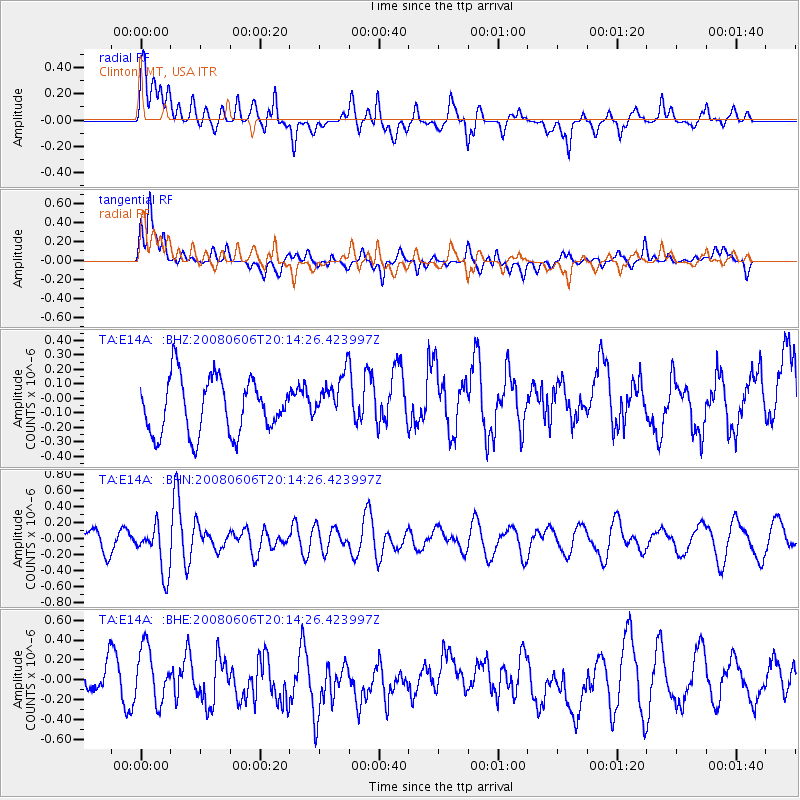
E14A Clinton, MT, USA - Earthquake Result Viewer
*The percent match for this event was below the threshold and hence no stack was calculated.
| Earthquake location: |
Northern Algeria |
| Earthquake latitude/longitude: |
35.9/-0.7 |
| Earthquake time(UTC): |
2008/06/06 (158) 20:02:56 GMT |
| Earthquake Depth: |
4.0 km |
| Earthquake Magnitude: |
5.5 MB, 5.3 MS, 5.5 MW, 5.5 MW |
| Earthquake Catalog/Contributor: |
WHDF/NEIC |
|
| Network: |
TA USArray Transportable Network (new EarthScope stations) |
| Station: |
E14A Clinton, MT, USA |
| Lat/Lon: |
46.42 N/113.49 W |
| Elevation: |
1675 m |
|
| Distance: |
78.3 deg |
| Az: |
319.366 deg |
| Baz: |
49.854 deg |
| Ray Param: |
$rayparam |
*The percent match for this event was below the threshold and hence was not used in the summary stack. |
|
| Radial Match: |
56.972725 % |
| Radial Bump: |
400 |
| Transverse Match: |
62.288033 % |
| Transverse Bump: |
400 |
| SOD ConfigId: |
2504 |
| Insert Time: |
2010-03-06 15:44:48.044 +0000 |
| GWidth: |
2.5 |
| Max Bumps: |
400 |
| Tol: |
0.001 |
|
Signal To Noise
| Channel | StoN | STA | LTA |
| TA:E14A: :BHN:20080606T20:14:26.423997Z | 1.5958968 | 2.9645213E-7 | 1.8575895E-7 |
| TA:E14A: :BHE:20080606T20:14:26.423997Z | 2.4558163 | 2.7025573E-7 | 1.1004721E-7 |
| TA:E14A: :BHZ:20080606T20:14:26.423997Z | 0.8676508 | 1.6443995E-7 | 1.8952319E-7 |
| Arrivals |
| Ps | |
| PpPs | |
| PsPs/PpSs | |


