You are here: Home > Network List > CI - Caltech Regional Seismic Network Stations List
> Station MPP McPhearson Peak > Earthquake Result Viewer
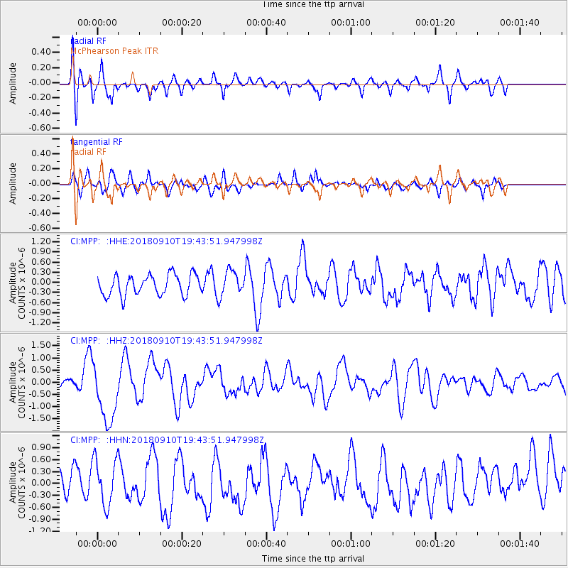
MPP McPhearson Peak - Earthquake Result Viewer
*The percent match for this event was below the threshold and hence no stack was calculated.
| Earthquake location: |
Southeast Of Loyalty Islands |
| Earthquake latitude/longitude: |
-22.1/170.0 |
| Earthquake time(UTC): |
2018/09/10 (253) 19:31:42 GMT |
| Earthquake Depth: |
10 km |
| Earthquake Magnitude: |
6.6 Mi |
| Earthquake Catalog/Contributor: |
NEIC PDE/at |
|
| Network: |
CI Caltech Regional Seismic Network |
| Station: |
MPP McPhearson Peak |
| Lat/Lon: |
34.89 N/119.81 W |
| Elevation: |
1739 m |
|
| Distance: |
87.4 deg |
| Az: |
50.732 deg |
| Baz: |
240.857 deg |
| Ray Param: |
$rayparam |
*The percent match for this event was below the threshold and hence was not used in the summary stack. |
|
| Radial Match: |
57.041977 % |
| Radial Bump: |
400 |
| Transverse Match: |
63.346684 % |
| Transverse Bump: |
400 |
| SOD ConfigId: |
13570011 |
| Insert Time: |
2019-05-01 05:19:34.568 +0000 |
| GWidth: |
2.5 |
| Max Bumps: |
400 |
| Tol: |
0.001 |
|
Signal To Noise
| Channel | StoN | STA | LTA |
| CI:MPP: :HHZ:20180910T19:43:51.947998Z | 7.108825 | 1.2427569E-6 | 1.7481888E-7 |
| CI:MPP: :HHN:20180910T19:43:51.947998Z | 1.9150977 | 5.8999797E-7 | 3.080772E-7 |
| CI:MPP: :HHE:20180910T19:43:51.947998Z | 2.2809918 | 7.354496E-7 | 3.2242534E-7 |
| Arrivals |
| Ps | |
| PpPs | |
| PsPs/PpSs | |


