You are here: Home > Network List > TA - USArray Transportable Network (new EarthScope stations) Stations List
> Station E14A Clinton, MT, USA > Earthquake Result Viewer
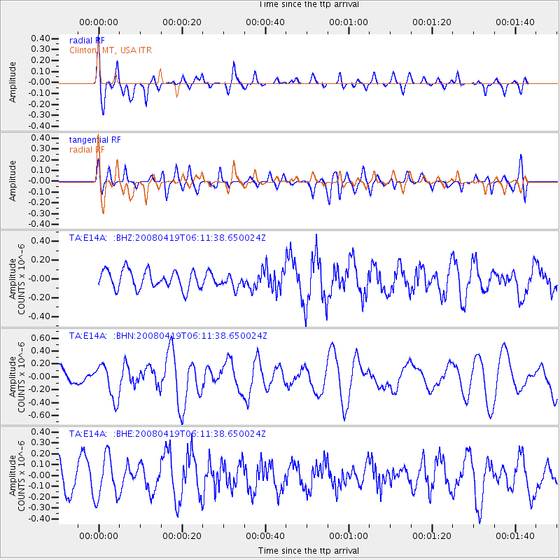
E14A Clinton, MT, USA - Earthquake Result Viewer
*The percent match for this event was below the threshold and hence no stack was calculated.
| Earthquake location: |
Loyalty Islands |
| Earthquake latitude/longitude: |
-20.3/168.8 |
| Earthquake time(UTC): |
2008/04/19 (110) 05:58:42 GMT |
| Earthquake Depth: |
14 km |
| Earthquake Magnitude: |
5.7 MB, 6.2 MS, 6.3 MW, 6.2 MW |
| Earthquake Catalog/Contributor: |
WHDF/NEIC |
|
| Network: |
TA USArray Transportable Network (new EarthScope stations) |
| Station: |
E14A Clinton, MT, USA |
| Lat/Lon: |
46.42 N/113.49 W |
| Elevation: |
1675 m |
|
| Distance: |
96.3 deg |
| Az: |
42.856 deg |
| Baz: |
247.36 deg |
| Ray Param: |
$rayparam |
*The percent match for this event was below the threshold and hence was not used in the summary stack. |
|
| Radial Match: |
59.5153 % |
| Radial Bump: |
400 |
| Transverse Match: |
48.99631 % |
| Transverse Bump: |
400 |
| SOD ConfigId: |
2504 |
| Insert Time: |
2010-03-06 15:45:16.304 +0000 |
| GWidth: |
2.5 |
| Max Bumps: |
400 |
| Tol: |
0.001 |
|
Signal To Noise
| Channel | StoN | STA | LTA |
| TA:E14A: :BHN:20080419T06:11:38.650024Z | 2.6326709 | 2.7608084E-7 | 1.0486721E-7 |
| TA:E14A: :BHE:20080419T06:11:38.650024Z | 1.5623801 | 1.9658388E-7 | 1.2582335E-7 |
| TA:E14A: :BHZ:20080419T06:11:38.650024Z | 0.72248816 | 7.0549255E-8 | 9.764763E-8 |
| Arrivals |
| Ps | |
| PpPs | |
| PsPs/PpSs | |


