You are here: Home > Network List > TA - USArray Transportable Network (new EarthScope stations) Stations List
> Station C17K DeLong Mountains, AK, USA > Earthquake Result Viewer
C17K DeLong Mountains, AK, USA - Earthquake Result Viewer
| Earthquake location: |
Southeast Of Loyalty Islands |
| Earthquake latitude/longitude: |
-22.1/170.0 |
| Earthquake time(UTC): |
2018/09/10 (253) 19:31:42 GMT |
| Earthquake Depth: |
10 km |
| Earthquake Magnitude: |
6.6 Mi |
| Earthquake Catalog/Contributor: |
NEIC PDE/at |
|
| Network: |
TA USArray Transportable Network (new EarthScope stations) |
| Station: |
C17K DeLong Mountains, AK, USA |
| Lat/Lon: |
68.48 N/163.18 W |
| Elevation: |
498 m |
|
| Distance: |
92.4 deg |
| Az: |
9.594 deg |
| Baz: |
204.762 deg |
| Ray Param: |
0.04146085 |
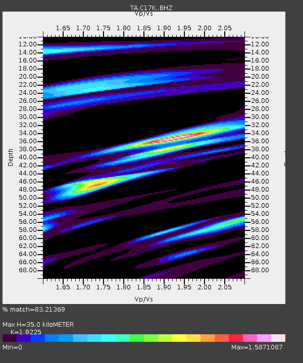
| Estimated Moho Depth: |
35.0 km |
| Estimated Crust Vp/Vs: |
1.92 |
| Assumed Crust Vp: |
5.906 km/s |
| Estimated Crust Vs: |
3.072 km/s |
| Estimated Crust Poisson's Ratio: |
0.31 |
|
| Radial Match: |
83.21369 % |
| Radial Bump: |
400 |
| Transverse Match: |
78.86405 % |
| Transverse Bump: |
400 |
| SOD ConfigId: |
13570011 |
| Insert Time: |
2019-05-01 05:21:59.662 +0000 |
| GWidth: |
2.5 |
| Max Bumps: |
400 |
| Tol: |
0.001 |
|

Signal To Noise
| Channel | StoN | STA | LTA |
| TA:C17K: :BHZ:20180910T19:44:15.674988Z | 8.268822 | 6.9246954E-7 | 8.3744645E-8 |
| TA:C17K: :BHN:20180910T19:44:15.674988Z | 2.6173923 | 1.6609123E-7 | 6.345676E-8 |
| TA:C17K: :BHE:20180910T19:44:15.674988Z | 2.1877918 | 1.6968986E-7 | 7.7562156E-8 |
| Arrivals |
| Ps | 5.6 SECOND |
| PpPs | 17 SECOND |
| PsPs/PpSs | 23 SECOND |


