You are here: Home > Network List > TA - USArray Transportable Network (new EarthScope stations) Stations List
> Station D23K Nanushuk River, AK USA > Earthquake Result Viewer
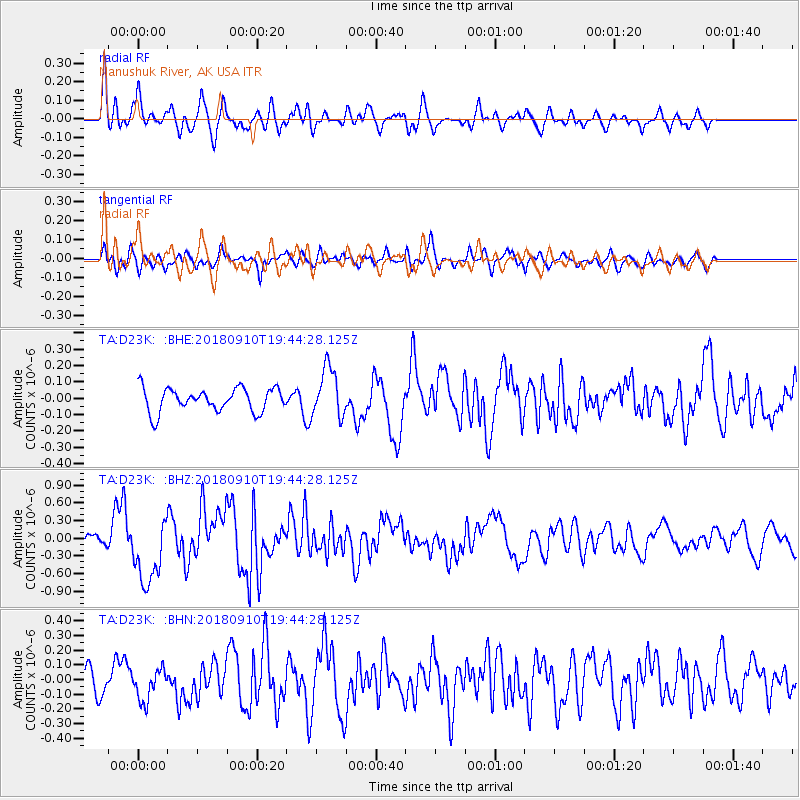
D23K Nanushuk River, AK USA - Earthquake Result Viewer
*The percent match for this event was below the threshold and hence no stack was calculated.
| Earthquake location: |
Southeast Of Loyalty Islands |
| Earthquake latitude/longitude: |
-22.1/170.0 |
| Earthquake time(UTC): |
2018/09/10 (253) 19:31:42 GMT |
| Earthquake Depth: |
10 km |
| Earthquake Magnitude: |
6.6 Mi |
| Earthquake Catalog/Contributor: |
NEIC PDE/at |
|
| Network: |
TA USArray Transportable Network (new EarthScope stations) |
| Station: |
D23K Nanushuk River, AK USA |
| Lat/Lon: |
68.97 N/150.68 W |
| Elevation: |
406 m |
|
| Distance: |
95.2 deg |
| Az: |
13.279 deg |
| Baz: |
216.159 deg |
| Ray Param: |
$rayparam |
*The percent match for this event was below the threshold and hence was not used in the summary stack. |
|
| Radial Match: |
70.0146 % |
| Radial Bump: |
400 |
| Transverse Match: |
68.4132 % |
| Transverse Bump: |
400 |
| SOD ConfigId: |
13570011 |
| Insert Time: |
2019-05-01 05:22:08.488 +0000 |
| GWidth: |
2.5 |
| Max Bumps: |
400 |
| Tol: |
0.001 |
|
Signal To Noise
| Channel | StoN | STA | LTA |
| TA:D23K: :BHZ:20180910T19:44:28.125Z | 6.2374578 | 5.676765E-7 | 9.101088E-8 |
| TA:D23K: :BHN:20180910T19:44:28.125Z | 1.621955 | 1.0644008E-7 | 6.5624555E-8 |
| TA:D23K: :BHE:20180910T19:44:28.125Z | 1.6845982 | 1.09314236E-7 | 6.4890386E-8 |
| Arrivals |
| Ps | |
| PpPs | |
| PsPs/PpSs | |


