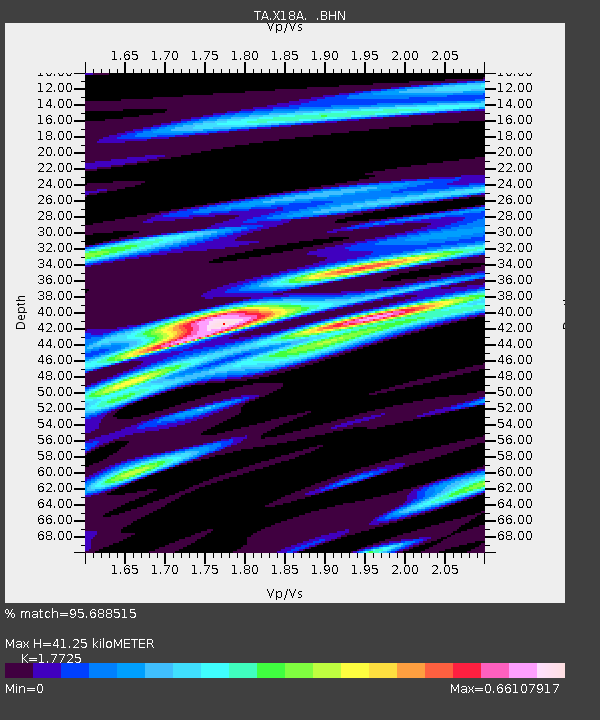
X18A Snowflake, AZ, USA - Earthquake Result Viewer
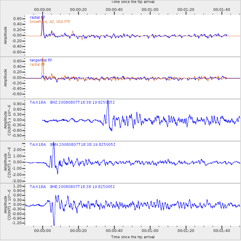
Earthquake location: Andreanof Islands, Aleutian Is.
Earthquake latitude/longitude: 52.2/-175.7
Earthquake time(UTC): 2008/08/07 (220) 18:30:03 GMT
Earthquake Depth: 12 km
Earthquake Magnitude: 5.6 MB, 5.5 MS, 5.8 MW, 5.8 MW
Earthquake Catalog/Contributor: WHDF/NEIC
Network: TA USArray Transportable Network (new EarthScope stations)
Station: X18A Snowflake, AZ, USA
Lat/Lon: 34.53 N/109.95 W
Elevation: 1751 m
Distance: 49.2 deg
Az: 83.959 deg
Baz: 312.14 deg
Ray Param: 0.06886645
Estimated Moho Depth: 41.25 km
Estimated Crust Vp/Vs: 1.77
Assumed Crust Vp: 6.496 km/s
Estimated Crust Vs: 3.665 km/s
Estimated Crust Poisson's Ratio: 0.27
Radial Match: 95.688515 %
Radial Bump: 332
Transverse Match: 79.54382 %
Transverse Bump: 400
SOD ConfigId: 2504
Insert Time: 2010-03-06 15:45:32.128 +0000
GWidth: 2.5
Max Bumps: 400
Tol: 0.001

Signal To Noise

ChannelStoNSTALTA
TA:X18A: :BHN:20080807T18:38:19.825005Z11.9394594.2425467E-73.5533827E-8
TA:X18A: :BHE:20080807T18:38:19.825005Z5.412081.9278926E-73.5622026E-8
TA:X18A: :BHZ:20080807T18:38:19.825005Z3.03581711.2867325E-74.2385043E-8
Arrivals
Ps5.2 SECOND
PpPs17 SECOND
PsPs/PpSs22 SECOND