You are here: Home > Network List > TA - USArray Transportable Network (new EarthScope stations) Stations List
> Station J26L Joseph Creek, AK, USA > Earthquake Result Viewer
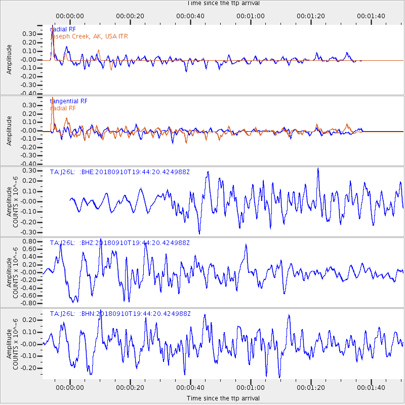
J26L Joseph Creek, AK, USA - Earthquake Result Viewer
*The percent match for this event was below the threshold and hence no stack was calculated.
| Earthquake location: |
Southeast Of Loyalty Islands |
| Earthquake latitude/longitude: |
-22.1/170.0 |
| Earthquake time(UTC): |
2018/09/10 (253) 19:31:42 GMT |
| Earthquake Depth: |
10 km |
| Earthquake Magnitude: |
6.6 Mi |
| Earthquake Catalog/Contributor: |
NEIC PDE/at |
|
| Network: |
TA USArray Transportable Network (new EarthScope stations) |
| Station: |
J26L Joseph Creek, AK, USA |
| Lat/Lon: |
64.50 N/143.56 W |
| Elevation: |
1144 m |
|
| Distance: |
93.5 deg |
| Az: |
18.314 deg |
| Baz: |
222.318 deg |
| Ray Param: |
$rayparam |
*The percent match for this event was below the threshold and hence was not used in the summary stack. |
|
| Radial Match: |
79.51369 % |
| Radial Bump: |
400 |
| Transverse Match: |
60.28811 % |
| Transverse Bump: |
400 |
| SOD ConfigId: |
13570011 |
| Insert Time: |
2019-05-01 05:23:02.960 +0000 |
| GWidth: |
2.5 |
| Max Bumps: |
400 |
| Tol: |
0.001 |
|
Signal To Noise
| Channel | StoN | STA | LTA |
| TA:J26L: :BHZ:20180910T19:44:20.424988Z | 6.3578243 | 5.4535906E-7 | 8.577763E-8 |
| TA:J26L: :BHN:20180910T19:44:20.424988Z | 2.183864 | 1.217512E-7 | 5.575036E-8 |
| TA:J26L: :BHE:20180910T19:44:20.424988Z | 1.7884281 | 9.984801E-8 | 5.5830036E-8 |
| Arrivals |
| Ps | |
| PpPs | |
| PsPs/PpSs | |


