You are here: Home > Network List > TA - USArray Transportable Network (new EarthScope stations) Stations List
> Station X18A Snowflake, AZ, USA > Earthquake Result Viewer
X18A Snowflake, AZ, USA - Earthquake Result Viewer

| Earthquake location: |
Central Mid-Atlantic Ridge |
| Earthquake latitude/longitude: |
8.1/-38.7 |
| Earthquake time(UTC): |
2008/09/10 (254) 13:08:14 GMT |
| Earthquake Depth: |
10 km |
| Earthquake Magnitude: |
6.3 MB, 6.5 MS, 6.6 MW, 6.6 MW |
| Earthquake Catalog/Contributor: |
WHDF/NEIC |
|
| Network: |
TA USArray Transportable Network (new EarthScope stations) |
| Station: |
X18A Snowflake, AZ, USA |
| Lat/Lon: |
34.53 N/109.95 W |
| Elevation: |
1751 m |
|
| Distance: |
70.0 deg |
| Az: |
303.711 deg |
| Baz: |
93.924 deg |
| Ray Param: |
0.055269413 |
| Estimated Moho Depth: |
31.0 km |
| Estimated Crust Vp/Vs: |
2.01 |
| Assumed Crust Vp: |
6.496 km/s |
| Estimated Crust Vs: |
3.232 km/s |
| Estimated Crust Poisson's Ratio: |
0.34 |
|
| Radial Match: |
94.5108 % |
| Radial Bump: |
275 |
| Transverse Match: |
79.79952 % |
| Transverse Bump: |
340 |
| SOD ConfigId: |
2560 |
| Insert Time: |
2010-03-06 15:45:51.947 +0000 |
| GWidth: |
2.5 |
| Max Bumps: |
400 |
| Tol: |
0.001 |
|
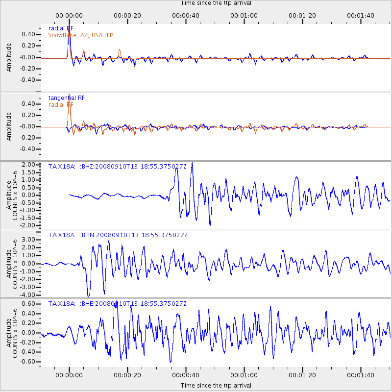
Signal To Noise
| Channel | StoN | STA | LTA |
| TA:X18A: :BHN:20080910T13:18:55.375027Z | 2.5795863 | 3.0966282E-7 | 1.2004361E-7 |
| TA:X18A: :BHE:20080910T13:18:55.375027Z | 1.7168895 | 1.297906E-7 | 7.559637E-8 |
| TA:X18A: :BHZ:20080910T13:18:55.375027Z | 1.6369426 | 1.3870799E-7 | 8.4736016E-8 |
| Arrivals |
| Ps | 5.0 SECOND |
| PpPs | 14 SECOND |
| PsPs/PpSs | 19 SECOND |


