You are here: Home > Network List > TA - USArray Transportable Network (new EarthScope stations) Stations List
> Station X18A Snowflake, AZ, USA > Earthquake Result Viewer
X18A Snowflake, AZ, USA - Earthquake Result Viewer
| Earthquake location: |
Vanuatu Islands |
| Earthquake latitude/longitude: |
-16.5/167.2 |
| Earthquake time(UTC): |
2008/03/12 (072) 11:36:55 GMT |
| Earthquake Depth: |
10 km |
| Earthquake Magnitude: |
5.6 MB, 6.3 MW |
| Earthquake Catalog/Contributor: |
WHDF/NEIC |
|
| Network: |
TA USArray Transportable Network (new EarthScope stations) |
| Station: |
X18A Snowflake, AZ, USA |
| Lat/Lon: |
34.53 N/109.95 W |
| Elevation: |
1751 m |
|
| Distance: |
93.5 deg |
| Az: |
55.159 deg |
| Baz: |
252.502 deg |
| Ray Param: |
0.0412512 |
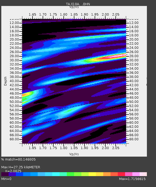
| Estimated Moho Depth: |
27.25 km |
| Estimated Crust Vp/Vs: |
2.08 |
| Assumed Crust Vp: |
6.496 km/s |
| Estimated Crust Vs: |
3.119 km/s |
| Estimated Crust Poisson's Ratio: |
0.35 |
|
| Radial Match: |
80.146805 % |
| Radial Bump: |
364 |
| Transverse Match: |
62.586315 % |
| Transverse Bump: |
400 |
| SOD ConfigId: |
2564 |
| Insert Time: |
2010-03-06 15:46:00.489 +0000 |
| GWidth: |
2.5 |
| Max Bumps: |
400 |
| Tol: |
0.001 |
|
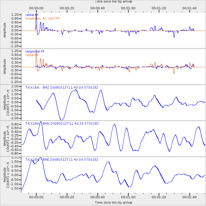
Signal To Noise
| Channel | StoN | STA | LTA |
| TA:X18A: :BHN:20080312T11:49:39.373018Z | 1.5507101 | 6.450919E-7 | 4.1599776E-7 |
| TA:X18A: :BHE:20080312T11:49:39.373018Z | 1.5861481 | 1.9299036E-6 | 1.2167235E-6 |
| TA:X18A: :BHZ:20080312T11:49:39.373018Z | 0.47791064 | 5.1209736E-7 | 1.0715337E-6 |
| Arrivals |
| Ps | 4.6 SECOND |
| PpPs | 13 SECOND |
| PsPs/PpSs | 17 SECOND |


