You are here: Home > Network List > TA - USArray Transportable Network (new EarthScope stations) Stations List
> Station R33M Jennings River, BC, CAN > Earthquake Result Viewer
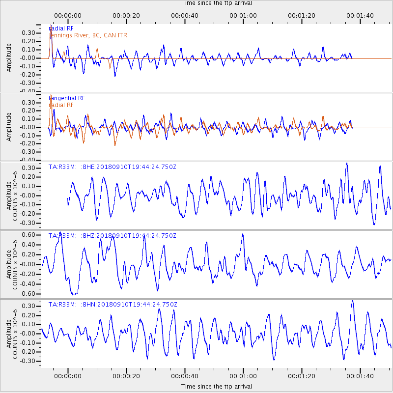
R33M Jennings River, BC, CAN - Earthquake Result Viewer
*The percent match for this event was below the threshold and hence no stack was calculated.
| Earthquake location: |
Southeast Of Loyalty Islands |
| Earthquake latitude/longitude: |
-22.1/170.0 |
| Earthquake time(UTC): |
2018/09/10 (253) 19:31:42 GMT |
| Earthquake Depth: |
10 km |
| Earthquake Magnitude: |
6.6 Mi |
| Earthquake Catalog/Contributor: |
NEIC PDE/at |
|
| Network: |
TA USArray Transportable Network (new EarthScope stations) |
| Station: |
R33M Jennings River, BC, CAN |
| Lat/Lon: |
59.39 N/130.97 W |
| Elevation: |
1437 m |
|
| Distance: |
94.4 deg |
| Az: |
26.106 deg |
| Baz: |
232.901 deg |
| Ray Param: |
$rayparam |
*The percent match for this event was below the threshold and hence was not used in the summary stack. |
|
| Radial Match: |
74.713974 % |
| Radial Bump: |
400 |
| Transverse Match: |
77.430855 % |
| Transverse Bump: |
400 |
| SOD ConfigId: |
13570011 |
| Insert Time: |
2019-05-01 05:24:02.460 +0000 |
| GWidth: |
2.5 |
| Max Bumps: |
400 |
| Tol: |
0.001 |
|
Signal To Noise
| Channel | StoN | STA | LTA |
| TA:R33M: :BHZ:20180910T19:44:24.750Z | 5.694764 | 4.3208084E-7 | 7.587335E-8 |
| TA:R33M: :BHN:20180910T19:44:24.750Z | 0.6319007 | 6.703471E-8 | 1.06084244E-7 |
| TA:R33M: :BHE:20180910T19:44:24.750Z | 1.3774412 | 1.4512625E-7 | 1.0535931E-7 |
| Arrivals |
| Ps | |
| PpPs | |
| PsPs/PpSs | |


