You are here: Home > Network List > TA - USArray Transportable Network (new EarthScope stations) Stations List
> Station X18A Snowflake, AZ, USA > Earthquake Result Viewer
X18A Snowflake, AZ, USA - Earthquake Result Viewer
| Earthquake location: |
Costa Rica |
| Earthquake latitude/longitude: |
10.2/-84.2 |
| Earthquake time(UTC): |
2009/01/08 (008) 19:21:35 GMT |
| Earthquake Depth: |
14 km |
| Earthquake Magnitude: |
5.7 MB, 6.0 MS, 6.1 MW, 6.1 MW |
| Earthquake Catalog/Contributor: |
WHDF/NEIC |
|
| Network: |
TA USArray Transportable Network (new EarthScope stations) |
| Station: |
X18A Snowflake, AZ, USA |
| Lat/Lon: |
34.53 N/109.95 W |
| Elevation: |
1751 m |
|
| Distance: |
33.8 deg |
| Az: |
319.842 deg |
| Baz: |
129.734 deg |
| Ray Param: |
0.07803403 |
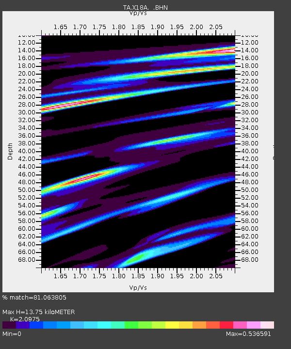
| Estimated Moho Depth: |
13.75 km |
| Estimated Crust Vp/Vs: |
2.10 |
| Assumed Crust Vp: |
6.496 km/s |
| Estimated Crust Vs: |
3.097 km/s |
| Estimated Crust Poisson's Ratio: |
0.35 |
|
| Radial Match: |
81.063805 % |
| Radial Bump: |
301 |
| Transverse Match: |
60.965454 % |
| Transverse Bump: |
400 |
| SOD ConfigId: |
2834 |
| Insert Time: |
2010-03-06 15:46:12.133 +0000 |
| GWidth: |
2.5 |
| Max Bumps: |
400 |
| Tol: |
0.001 |
|
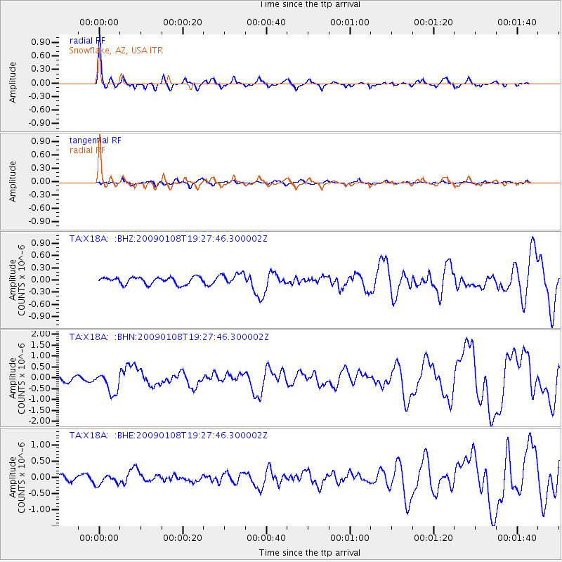
Signal To Noise
| Channel | StoN | STA | LTA |
| TA:X18A: :BHN:20090108T19:27:46.300002Z | 3.2499015 | 4.853232E-7 | 1.4933475E-7 |
| TA:X18A: :BHE:20090108T19:27:46.300002Z | 1.0855274 | 1.4167905E-7 | 1.3051633E-7 |
| TA:X18A: :BHZ:20090108T19:27:46.300002Z | 1.6584544 | 1.4069171E-7 | 8.4833026E-8 |
| Arrivals |
| Ps | 2.5 SECOND |
| PpPs | 6.1 SECOND |
| PsPs/PpSs | 8.6 SECOND |


