You are here: Home > Network List > TA - USArray Transportable Network (new EarthScope stations) Stations List
> Station X18A Snowflake, AZ, USA > Earthquake Result Viewer
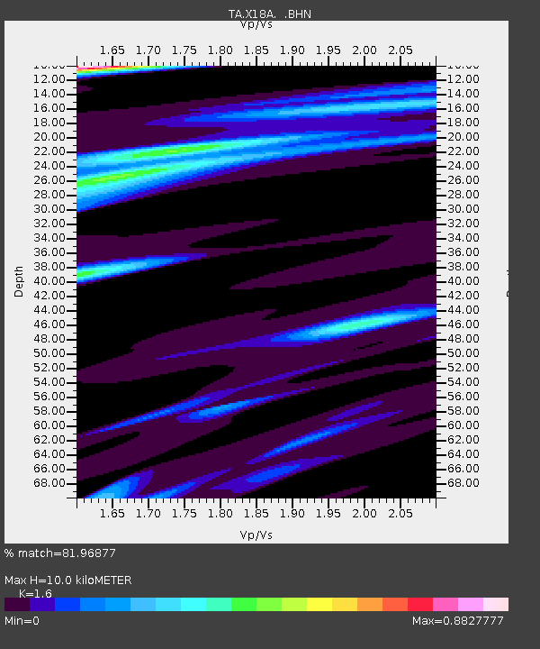
X18A Snowflake, AZ, USA - Earthquake Result Viewer
| Earthquake location: |
Southeast Of Loyalty Islands |
| Earthquake latitude/longitude: |
-22.4/170.6 |
| Earthquake time(UTC): |
2009/01/15 (015) 07:27:20 GMT |
| Earthquake Depth: |
27 km |
| Earthquake Magnitude: |
5.8 MB, 6.5 MS, 6.7 MW, 6.6 MW |
| Earthquake Catalog/Contributor: |
WHDF/NEIC |
|
| Network: |
TA USArray Transportable Network (new EarthScope stations) |
| Station: |
X18A Snowflake, AZ, USA |
| Lat/Lon: |
34.53 N/109.95 W |
| Elevation: |
1751 m |
|
| Distance: |
94.2 deg |
| Az: |
54.462 deg |
| Baz: |
245.844 deg |
| Ray Param: |
0.041093815 |
| Estimated Moho Depth: |
10.0 km |
| Estimated Crust Vp/Vs: |
1.60 |
| Assumed Crust Vp: |
6.496 km/s |
| Estimated Crust Vs: |
4.06 km/s |
| Estimated Crust Poisson's Ratio: |
0.18 |
|
| Radial Match: |
81.96877 % |
| Radial Bump: |
299 |
| Transverse Match: |
66.025734 % |
| Transverse Bump: |
307 |
| SOD ConfigId: |
2834 |
| Insert Time: |
2010-03-06 15:46:13.652 +0000 |
| GWidth: |
2.5 |
| Max Bumps: |
400 |
| Tol: |
0.001 |
|

Signal To Noise
| Channel | StoN | STA | LTA |
| TA:X18A: :BHN:20090115T07:40:05.099021Z | 1.7321206 | 5.273479E-7 | 3.044522E-7 |
| TA:X18A: :BHE:20090115T07:40:05.099021Z | 0.7709191 | 1.5870326E-7 | 2.058624E-7 |
| TA:X18A: :BHZ:20090115T07:40:05.099021Z | 1.6711481 | 2.4238722E-7 | 1.4504234E-7 |
| Arrivals |
| Ps | 0.9 SECOND |
| PpPs | 3.9 SECOND |
| PsPs/PpSs | 4.9 SECOND |


