You are here: Home > Network List > UW - Pacific Northwest Regional Seismic Network Stations List
> Station UMAT Pilot Rock, OR, USA > Earthquake Result Viewer
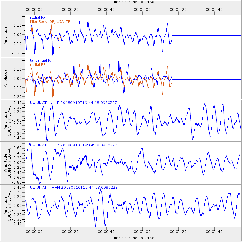
UMAT Pilot Rock, OR, USA - Earthquake Result Viewer
*The percent match for this event was below the threshold and hence no stack was calculated.
| Earthquake location: |
Southeast Of Loyalty Islands |
| Earthquake latitude/longitude: |
-22.1/170.0 |
| Earthquake time(UTC): |
2018/09/10 (253) 19:31:42 GMT |
| Earthquake Depth: |
10 km |
| Earthquake Magnitude: |
6.6 Mi |
| Earthquake Catalog/Contributor: |
NEIC PDE/at |
|
| Network: |
UW Pacific Northwest Regional Seismic Network |
| Station: |
UMAT Pilot Rock, OR, USA |
| Lat/Lon: |
45.29 N/118.96 W |
| Elevation: |
1318 m |
|
| Distance: |
93.0 deg |
| Az: |
41.952 deg |
| Baz: |
241.437 deg |
| Ray Param: |
$rayparam |
*The percent match for this event was below the threshold and hence was not used in the summary stack. |
|
| Radial Match: |
73.39108 % |
| Radial Bump: |
400 |
| Transverse Match: |
74.993996 % |
| Transverse Bump: |
400 |
| SOD ConfigId: |
13570011 |
| Insert Time: |
2019-05-01 05:24:53.656 +0000 |
| GWidth: |
2.5 |
| Max Bumps: |
400 |
| Tol: |
0.001 |
|
Signal To Noise
| Channel | StoN | STA | LTA |
| UW:UMAT: :HHZ:20180910T19:44:18.098022Z | 2.486365 | 5.6689584E-7 | 2.2800185E-7 |
| UW:UMAT: :HHN:20180910T19:44:18.098022Z | 0.93791974 | 1.6826256E-7 | 1.7939973E-7 |
| UW:UMAT: :HHE:20180910T19:44:18.098022Z | 1.2211823 | 2.0256118E-7 | 1.65873E-7 |
| Arrivals |
| Ps | |
| PpPs | |
| PsPs/PpSs | |


