You are here: Home > Network List > TA - USArray Transportable Network (new EarthScope stations) Stations List
> Station X18A Snowflake, AZ, USA > Earthquake Result Viewer
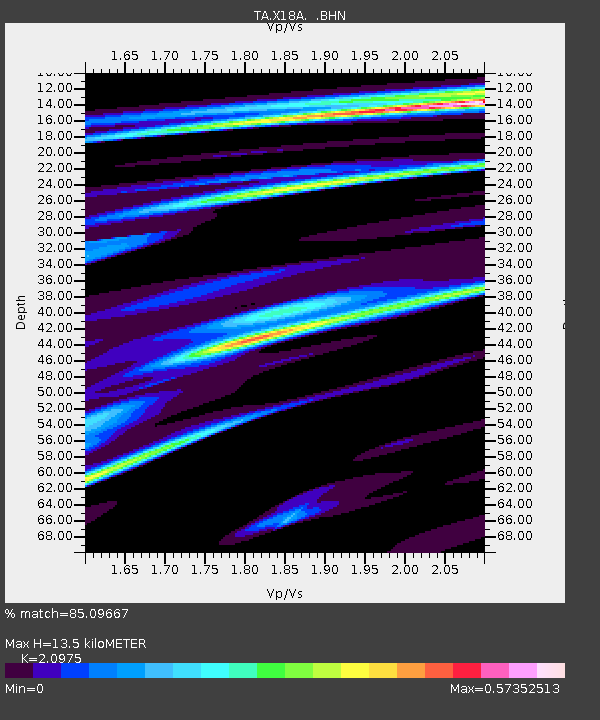
X18A Snowflake, AZ, USA - Earthquake Result Viewer
| Earthquake location: |
Off Coast Of Costa Rica |
| Earthquake latitude/longitude: |
7.9/-85.6 |
| Earthquake time(UTC): |
2009/08/13 (225) 09:37:35 GMT |
| Earthquake Depth: |
10 km |
| Earthquake Magnitude: |
5.8 MW, 5.3 MB |
| Earthquake Catalog/Contributor: |
WHDF/NEIC |
|
| Network: |
TA USArray Transportable Network (new EarthScope stations) |
| Station: |
X18A Snowflake, AZ, USA |
| Lat/Lon: |
34.53 N/109.95 W |
| Elevation: |
1751 m |
|
| Distance: |
34.6 deg |
| Az: |
323.266 deg |
| Baz: |
134.146 deg |
| Ray Param: |
0.07763707 |
| Estimated Moho Depth: |
13.5 km |
| Estimated Crust Vp/Vs: |
2.10 |
| Assumed Crust Vp: |
6.496 km/s |
| Estimated Crust Vs: |
3.097 km/s |
| Estimated Crust Poisson's Ratio: |
0.35 |
|
| Radial Match: |
85.09667 % |
| Radial Bump: |
299 |
| Transverse Match: |
71.95619 % |
| Transverse Bump: |
400 |
| SOD ConfigId: |
2622 |
| Insert Time: |
2010-03-06 15:46:25.330 +0000 |
| GWidth: |
2.5 |
| Max Bumps: |
400 |
| Tol: |
0.001 |
|

Signal To Noise
| Channel | StoN | STA | LTA |
| TA:X18A: :BHN:20090813T09:43:53.950006Z | 4.664156 | 2.3064258E-7 | 4.9450016E-8 |
| TA:X18A: :BHE:20090813T09:43:53.950006Z | 2.6527169 | 1.1115919E-7 | 4.1903903E-8 |
| TA:X18A: :BHZ:20090813T09:43:53.950006Z | 3.801393 | 1.2049368E-7 | 3.1697244E-8 |
| Arrivals |
| Ps | 2.4 SECOND |
| PpPs | 6.0 SECOND |
| PsPs/PpSs | 8.5 SECOND |


