You are here: Home > Network List > TA - USArray Transportable Network (new EarthScope stations) Stations List
> Station X18A Snowflake, AZ, USA > Earthquake Result Viewer
X18A Snowflake, AZ, USA - Earthquake Result Viewer
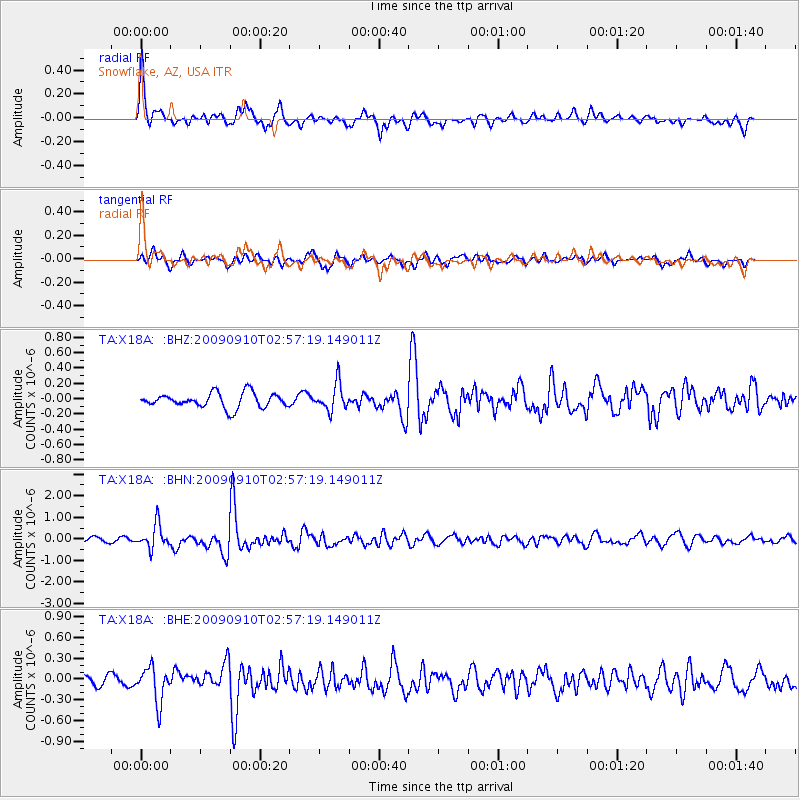
| Earthquake location: |
Kuril Islands |
| Earthquake latitude/longitude: |
48.3/154.2 |
| Earthquake time(UTC): |
2009/09/10 (253) 02:46:50 GMT |
| Earthquake Depth: |
36 km |
| Earthquake Magnitude: |
6.0 MB, 5.5 MS, 6.0 MW, 5.8 MW |
| Earthquake Catalog/Contributor: |
WHDF/NEIC |
|
| Network: |
TA USArray Transportable Network (new EarthScope stations) |
| Station: |
X18A Snowflake, AZ, USA |
| Lat/Lon: |
34.53 N/109.95 W |
| Elevation: |
1751 m |
|
| Distance: |
68.7 deg |
| Az: |
61.854 deg |
| Baz: |
314.53 deg |
| Ray Param: |
0.056100186 |
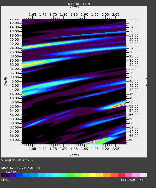
| Estimated Moho Depth: |
50.75 km |
| Estimated Crust Vp/Vs: |
2.09 |
| Assumed Crust Vp: |
6.496 km/s |
| Estimated Crust Vs: |
3.108 km/s |
| Estimated Crust Poisson's Ratio: |
0.35 |
|
| Radial Match: |
85.65967 % |
| Radial Bump: |
386 |
| Transverse Match: |
75.63063 % |
| Transverse Bump: |
400 |
| SOD ConfigId: |
2622 |
| Insert Time: |
2010-03-06 15:46:35.248 +0000 |
| GWidth: |
2.5 |
| Max Bumps: |
400 |
| Tol: |
0.001 |
|
Signal To Noise
| Channel | StoN | STA | LTA |
| TA:X18A: :BHN:20090910T02:57:19.149011Z | 5.7068152 | 5.516551E-7 | 9.6666014E-8 |
| TA:X18A: :BHE:20090910T02:57:19.149011Z | 2.900542 | 2.5057827E-7 | 8.639015E-8 |
| TA:X18A: :BHZ:20090910T02:57:19.149011Z | 1.8291041 | 1.7469088E-7 | 9.550626E-8 |
| Arrivals |
| Ps | 8.8 SECOND |
| PpPs | 23 SECOND |
| PsPs/PpSs | 32 SECOND |


