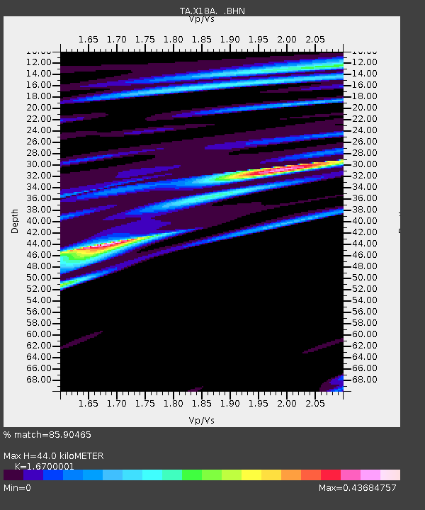
X18A Snowflake, AZ, USA - Earthquake Result Viewer

Earthquake location: Fox Islands, Aleutian Islands
Earthquake latitude/longitude: 52.6/-167.1
Earthquake time(UTC): 2009/10/13 (286) 20:21:53 GMT
Earthquake Depth: 14 km
Earthquake Magnitude: 5.9 MB, 6.4 MS, 6.4 MW, 6.4 MW
Earthquake Catalog/Contributor: WHDF/NEIC
Network: TA USArray Transportable Network (new EarthScope stations)
Station: X18A Snowflake, AZ, USA
Lat/Lon: 34.53 N/109.95 W
Elevation: 1751 m
Distance: 43.9 deg
Az: 90.876 deg
Baz: 312.385 deg
Ray Param: 0.07221932
Estimated Moho Depth: 44.0 km
Estimated Crust Vp/Vs: 1.67
Assumed Crust Vp: 6.496 km/s
Estimated Crust Vs: 3.89 km/s
Estimated Crust Poisson's Ratio: 0.22
Radial Match: 85.90465 %
Radial Bump: 400
Transverse Match: 47.365067 %
Transverse Bump: 400
SOD ConfigId: 2622
Insert Time: 2010-03-06 15:46:50.905 +0000
GWidth: 2.5
Max Bumps: 400
Tol: 0.001

Signal To Noise

ChannelStoNSTALTA
TA:X18A: :BHN:20091013T20:29:28.624011Z4.7759435.675273E-71.1883043E-7
TA:X18A: :BHE:20091013T20:29:28.624011Z2.02143294.1166209E-72.0364865E-7
TA:X18A: :BHZ:20091013T20:29:28.624011Z1.68436132.1204264E-71.2588904E-7
Arrivals
Ps4.9 SECOND
PpPs17 SECOND
PsPs/PpSs22 SECOND