You are here: Home > Network List > TA - USArray Transportable Network (new EarthScope stations) Stations List
> Station X18A Snowflake, AZ, USA > Earthquake Result Viewer
X18A Snowflake, AZ, USA - Earthquake Result Viewer
| Earthquake location: |
South Of Tonga Islands |
| Earthquake latitude/longitude: |
-24.1/-175.2 |
| Earthquake time(UTC): |
2009/11/02 (306) 10:47:13 GMT |
| Earthquake Depth: |
9.0 km |
| Earthquake Magnitude: |
6.1 MB, 6.1 MS, 6.2 MW, 6.1 MW |
| Earthquake Catalog/Contributor: |
WHDF/NEIC |
|
| Network: |
TA USArray Transportable Network (new EarthScope stations) |
| Station: |
X18A Snowflake, AZ, USA |
| Lat/Lon: |
34.53 N/109.95 W |
| Elevation: |
1751 m |
|
| Distance: |
85.0 deg |
| Az: |
48.803 deg |
| Baz: |
236.381 deg |
| Ray Param: |
0.04506806 |
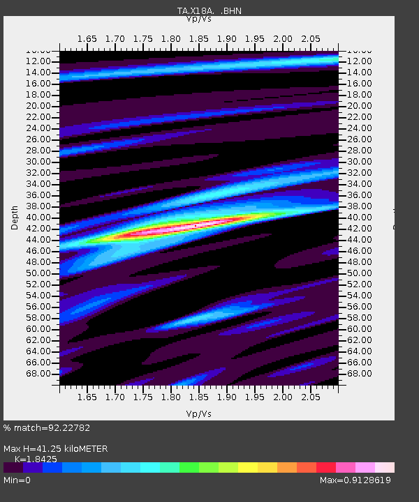
| Estimated Moho Depth: |
41.25 km |
| Estimated Crust Vp/Vs: |
1.84 |
| Assumed Crust Vp: |
6.496 km/s |
| Estimated Crust Vs: |
3.526 km/s |
| Estimated Crust Poisson's Ratio: |
0.29 |
|
| Radial Match: |
92.22782 % |
| Radial Bump: |
299 |
| Transverse Match: |
80.5384 % |
| Transverse Bump: |
400 |
| SOD ConfigId: |
2622 |
| Insert Time: |
2010-03-06 15:46:52.505 +0000 |
| GWidth: |
2.5 |
| Max Bumps: |
400 |
| Tol: |
0.001 |
|

Signal To Noise
| Channel | StoN | STA | LTA |
| TA:X18A: :BHN:20091102T10:59:17.50001Z | 10.270086 | 1.7075654E-6 | 1.6626592E-7 |
| TA:X18A: :BHE:20091102T10:59:17.50001Z | 1.9240091 | 2.8033014E-7 | 1.4570105E-7 |
| TA:X18A: :BHZ:20091102T10:59:17.50001Z | 4.7399836 | 5.940832E-7 | 1.2533444E-7 |
| Arrivals |
| Ps | 5.5 SECOND |
| PpPs | 18 SECOND |
| PsPs/PpSs | 23 SECOND |


