You are here: Home > Network List > US - United States National Seismic Network Stations List
> Station MSO Missoula, Montana, USA > Earthquake Result Viewer
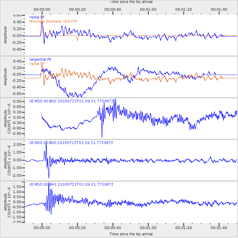
MSO Missoula, Montana, USA - Earthquake Result Viewer
*The percent match for this event was below the threshold and hence no stack was calculated.
| Earthquake location: |
Northwest Of Kuril Islands |
| Earthquake latitude/longitude: |
47.7/147.0 |
| Earthquake time(UTC): |
2016/07/23 (205) 01:00:21 GMT |
| Earthquake Depth: |
407 km |
| Earthquake Magnitude: |
5.7 MB |
| Earthquake Catalog/Contributor: |
NEIC PDE/NEIC ALERT |
|
| Network: |
US United States National Seismic Network |
| Station: |
MSO Missoula, Montana, USA |
| Lat/Lon: |
46.83 N/113.94 W |
| Elevation: |
1264 m |
|
| Distance: |
62.4 deg |
| Az: |
49.887 deg |
| Baz: |
311.213 deg |
| Ray Param: |
$rayparam |
*The percent match for this event was below the threshold and hence was not used in the summary stack. |
|
| Radial Match: |
52.533863 % |
| Radial Bump: |
400 |
| Transverse Match: |
25.189974 % |
| Transverse Bump: |
400 |
| SOD ConfigId: |
1634031 |
| Insert Time: |
2016-08-06 01:17:01.042 +0000 |
| GWidth: |
2.5 |
| Max Bumps: |
400 |
| Tol: |
0.001 |
|
Signal To Noise
| Channel | StoN | STA | LTA |
| US:MSO:00:BHZ:20160723T01:09:31.773987Z | 14.536733 | 9.2427996E-7 | 6.358237E-8 |
| US:MSO:00:BH1:20160723T01:09:31.773987Z | 3.8689878 | 6.8120727E-7 | 1.760686E-7 |
| US:MSO:00:BH2:20160723T01:09:31.773987Z | 3.5394218 | 6.080138E-7 | 1.7178336E-7 |
| Arrivals |
| Ps | |
| PpPs | |
| PsPs/PpSs | |


