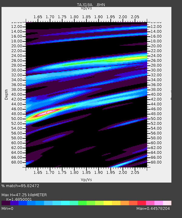
X18A Snowflake, AZ, USA - Earthquake Result Viewer
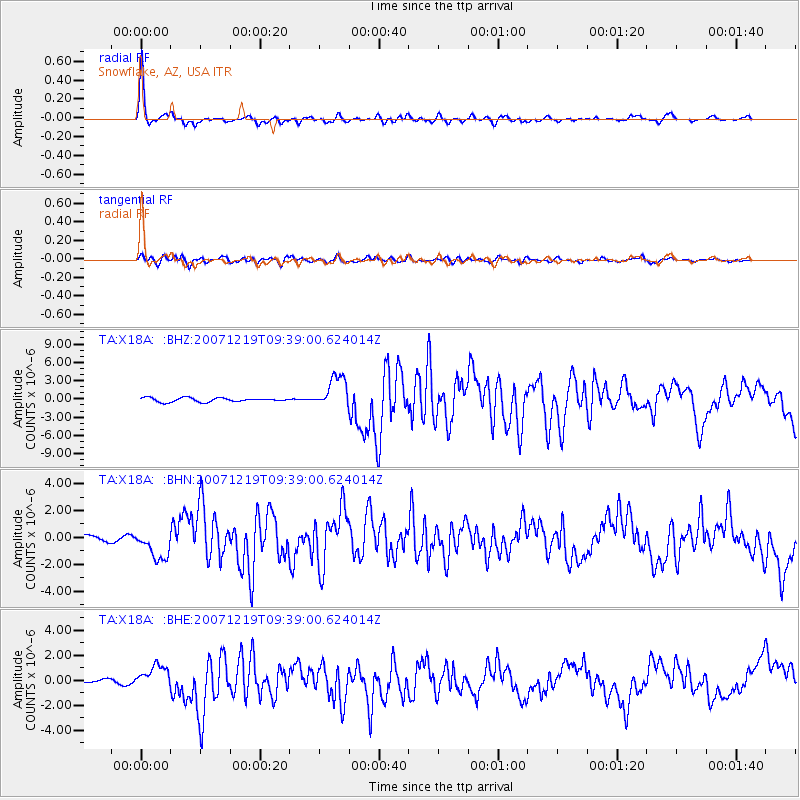
Earthquake location: Andreanof Islands, Aleutian Is.
Earthquake latitude/longitude: 51.4/-179.5
Earthquake time(UTC): 2007/12/19 (353) 09:30:27 GMT
Earthquake Depth: 29 km
Earthquake Magnitude: 6.4 MB, 7.1 MS, 7.1 MW, 7.0 MW
Earthquake Catalog/Contributor: WHDF/NEIC
Network: TA USArray Transportable Network (new EarthScope stations)
Station: X18A Snowflake, AZ, USA
Lat/Lon: 34.53 N/109.95 W
Elevation: 1751 m
Distance: 51.7 deg
Az: 80.516 deg
Baz: 311.497 deg
Ray Param: 0.06721203
Estimated Moho Depth: 47.25 km
Estimated Crust Vp/Vs: 1.69
Assumed Crust Vp: 6.496 km/s
Estimated Crust Vs: 3.855 km/s
Estimated Crust Poisson's Ratio: 0.23
Radial Match: 95.82472 %
Radial Bump: 315
Transverse Match: 77.810715 %
Transverse Bump: 400
SOD ConfigId: 2564
Insert Time: 2010-03-06 15:47:26.281 +0000
GWidth: 2.5
Max Bumps: 400
Tol: 0.001

Signal To Noise

ChannelStoNSTALTA
TA:X18A: :BHN:20071219T09:39:00.624014Z2.98845311.0969545E-63.670643E-7
TA:X18A: :BHE:20071219T09:39:00.624014Z4.4060599.578589E-72.1739585E-7
TA:X18A: :BHZ:20071219T09:39:00.624014Z8.1715612.667947E-63.2649172E-7
Arrivals
Ps5.3 SECOND
PpPs18 SECOND
PsPs/PpSs24 SECOND