You are here: Home > Network List > TA - USArray Transportable Network (new EarthScope stations) Stations List
> Station X18A Snowflake, AZ, USA > Earthquake Result Viewer
X18A Snowflake, AZ, USA - Earthquake Result Viewer
| Earthquake location: |
Kermadec Islands, New Zealand |
| Earthquake latitude/longitude: |
-30.0/-177.9 |
| Earthquake time(UTC): |
2007/11/20 (324) 15:28:28 GMT |
| Earthquake Depth: |
59 km |
| Earthquake Magnitude: |
6.0 MB, 5.9 MW, 5.8 MW |
| Earthquake Catalog/Contributor: |
WHDF/NEIC |
|
| Network: |
TA USArray Transportable Network (new EarthScope stations) |
| Station: |
X18A Snowflake, AZ, USA |
| Lat/Lon: |
34.53 N/109.95 W |
| Elevation: |
1751 m |
|
| Distance: |
90.7 deg |
| Az: |
49.945 deg |
| Baz: |
233.512 deg |
| Ray Param: |
0.041643586 |
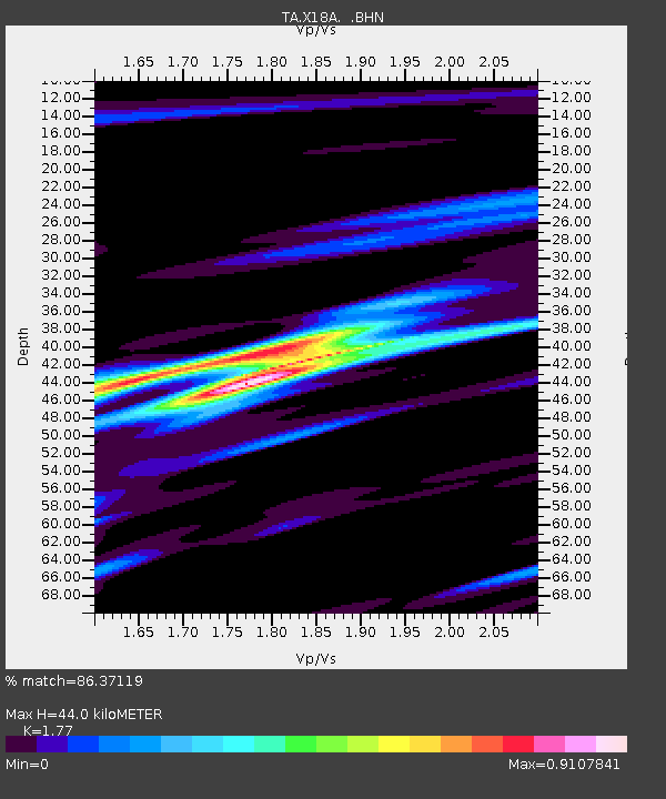
| Estimated Moho Depth: |
44.0 km |
| Estimated Crust Vp/Vs: |
1.77 |
| Assumed Crust Vp: |
6.496 km/s |
| Estimated Crust Vs: |
3.67 km/s |
| Estimated Crust Poisson's Ratio: |
0.27 |
|
| Radial Match: |
86.37119 % |
| Radial Bump: |
400 |
| Transverse Match: |
66.2788 % |
| Transverse Bump: |
400 |
| SOD ConfigId: |
2564 |
| Insert Time: |
2010-03-06 15:47:35.211 +0000 |
| GWidth: |
2.5 |
| Max Bumps: |
400 |
| Tol: |
0.001 |
|
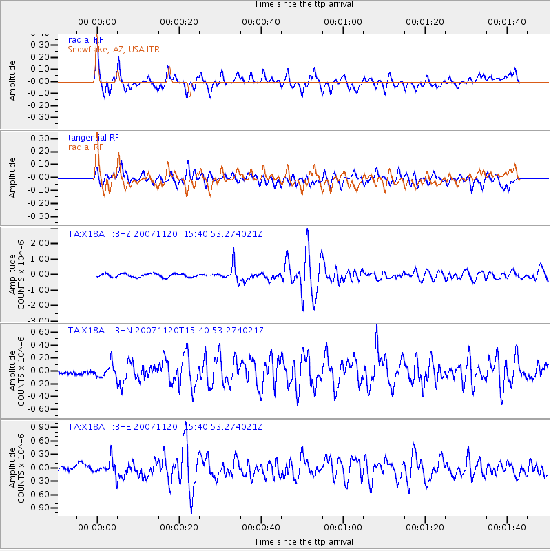
Signal To Noise
| Channel | StoN | STA | LTA |
| TA:X18A: :BHN:20071120T15:40:53.274021Z | 1.238931 | 1.09125686E-7 | 8.808052E-8 |
| TA:X18A: :BHE:20071120T15:40:53.274021Z | 1.6055636 | 1.7362002E-7 | 1.081365E-7 |
| TA:X18A: :BHZ:20071120T15:40:53.274021Z | 4.8485785 | 5.173552E-7 | 1.06702444E-7 |
| Arrivals |
| Ps | 5.3 SECOND |
| PpPs | 18 SECOND |
| PsPs/PpSs | 24 SECOND |


