You are here: Home > Network List > TA - USArray Transportable Network (new EarthScope stations) Stations List
> Station X18A Snowflake, AZ, USA > Earthquake Result Viewer
X18A Snowflake, AZ, USA - Earthquake Result Viewer
| Earthquake location: |
Jujuy Province, Argentina |
| Earthquake latitude/longitude: |
-22.6/-66.3 |
| Earthquake time(UTC): |
2007/11/18 (322) 05:40:12 GMT |
| Earthquake Depth: |
246 km |
| Earthquake Magnitude: |
5.7 MB, 6.0 MW, 6.0 MW |
| Earthquake Catalog/Contributor: |
WHDF/NEIC |
|
| Network: |
TA USArray Transportable Network (new EarthScope stations) |
| Station: |
X18A Snowflake, AZ, USA |
| Lat/Lon: |
34.53 N/109.95 W |
| Elevation: |
1751 m |
|
| Distance: |
70.4 deg |
| Az: |
322.784 deg |
| Baz: |
137.407 deg |
| Ray Param: |
0.05433325 |
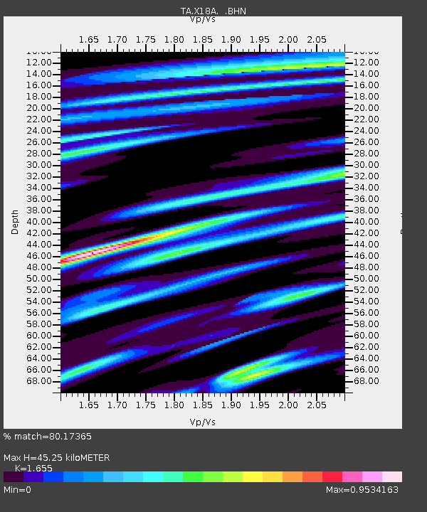
| Estimated Moho Depth: |
45.25 km |
| Estimated Crust Vp/Vs: |
1.65 |
| Assumed Crust Vp: |
6.496 km/s |
| Estimated Crust Vs: |
3.925 km/s |
| Estimated Crust Poisson's Ratio: |
0.21 |
|
| Radial Match: |
80.17365 % |
| Radial Bump: |
400 |
| Transverse Match: |
73.367294 % |
| Transverse Bump: |
400 |
| SOD ConfigId: |
2564 |
| Insert Time: |
2010-03-06 15:47:38.934 +0000 |
| GWidth: |
2.5 |
| Max Bumps: |
400 |
| Tol: |
0.001 |
|
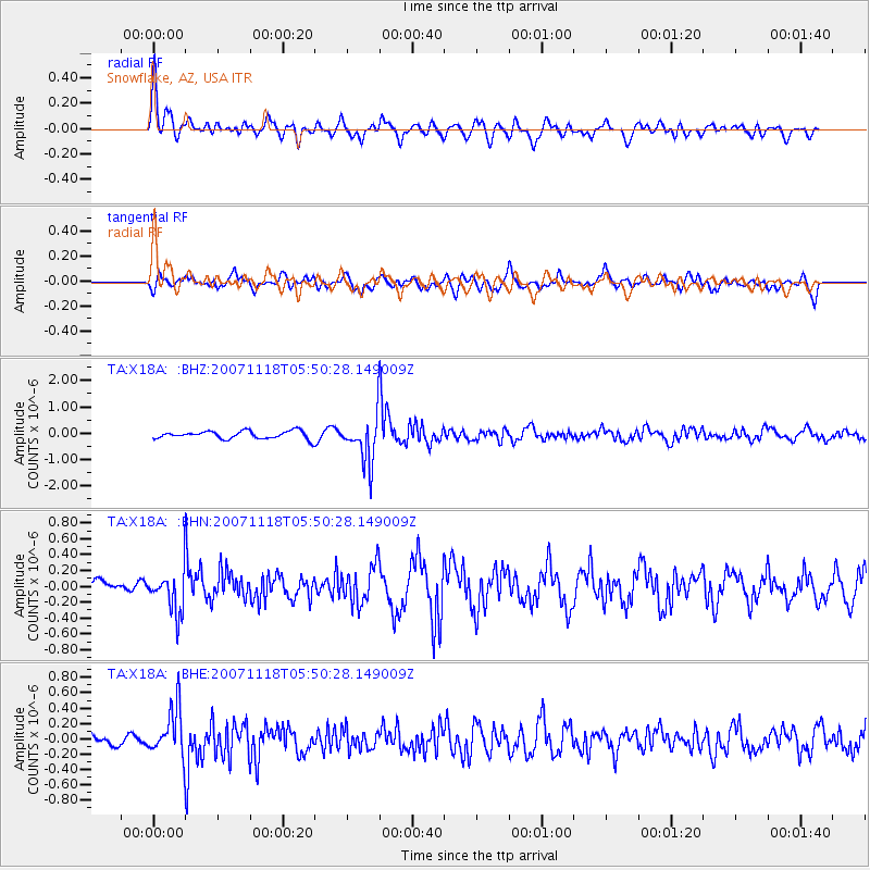
Signal To Noise
| Channel | StoN | STA | LTA |
| TA:X18A: :BHN:20071118T05:50:28.149009Z | 2.188432 | 2.5438501E-7 | 1.1624076E-7 |
| TA:X18A: :BHE:20071118T05:50:28.149009Z | 3.1357625 | 3.1079537E-7 | 9.911318E-8 |
| TA:X18A: :BHZ:20071118T05:50:28.149009Z | 6.0908756 | 8.9037223E-7 | 1.461813E-7 |
| Arrivals |
| Ps | 4.7 SECOND |
| PpPs | 18 SECOND |
| PsPs/PpSs | 23 SECOND |


