You are here: Home > Network List > TA - USArray Transportable Network (new EarthScope stations) Stations List
> Station X18A Snowflake, AZ, USA > Earthquake Result Viewer
X18A Snowflake, AZ, USA - Earthquake Result Viewer
| Earthquake location: |
Santa Cruz Islands |
| Earthquake latitude/longitude: |
-11.4/166.3 |
| Earthquake time(UTC): |
2007/08/12 (224) 12:05:19 GMT |
| Earthquake Depth: |
42 km |
| Earthquake Magnitude: |
5.8 MB, 5.7 MS, 6.0 MW, 6.0 MW |
| Earthquake Catalog/Contributor: |
WHDF/NEIC |
|
| Network: |
TA USArray Transportable Network (new EarthScope stations) |
| Station: |
X18A Snowflake, AZ, USA |
| Lat/Lon: |
34.53 N/109.95 W |
| Elevation: |
1751 m |
|
| Distance: |
91.3 deg |
| Az: |
55.181 deg |
| Baz: |
257.181 deg |
| Ray Param: |
0.04160533 |
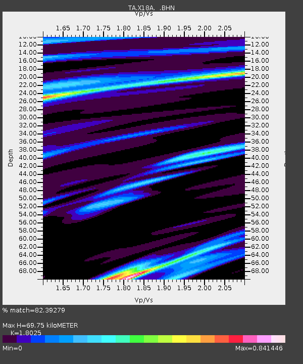
| Estimated Moho Depth: |
69.75 km |
| Estimated Crust Vp/Vs: |
1.80 |
| Assumed Crust Vp: |
6.496 km/s |
| Estimated Crust Vs: |
3.604 km/s |
| Estimated Crust Poisson's Ratio: |
0.28 |
|
| Radial Match: |
82.39279 % |
| Radial Bump: |
400 |
| Transverse Match: |
62.120056 % |
| Transverse Bump: |
379 |
| SOD ConfigId: |
2564 |
| Insert Time: |
2010-03-06 15:48:15.153 +0000 |
| GWidth: |
2.5 |
| Max Bumps: |
400 |
| Tol: |
0.001 |
|
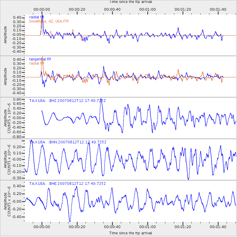
Signal To Noise
| Channel | StoN | STA | LTA |
| TA:X18A: :BHN:20070812T12:17:49.725Z | 1.047507 | 1.5366388E-7 | 1.4669483E-7 |
| TA:X18A: :BHE:20070812T12:17:49.725Z | 1.7193353 | 1.761788E-7 | 1.0246914E-7 |
| TA:X18A: :BHZ:20070812T12:17:49.725Z | 2.7173104 | 3.5679287E-7 | 1.3130368E-7 |
| Arrivals |
| Ps | 8.8 SECOND |
| PpPs | 29 SECOND |
| PsPs/PpSs | 38 SECOND |


