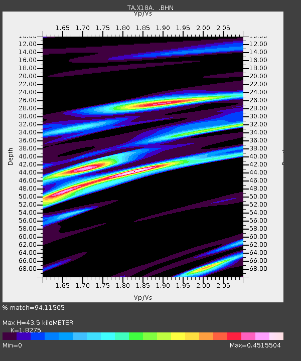
X18A Snowflake, AZ, USA - Earthquake Result Viewer

Earthquake location: Andreanof Islands, Aleutian Is.
Earthquake latitude/longitude: 51.8/-176.3
Earthquake time(UTC): 2007/07/13 (194) 21:54:43 GMT
Earthquake Depth: 35 km
Earthquake Magnitude: 5.7 MB, 5.6 MS, 6.0 MW, 5.9 MW
Earthquake Catalog/Contributor: WHDF/NEIC
Network: TA USArray Transportable Network (new EarthScope stations)
Station: X18A Snowflake, AZ, USA
Lat/Lon: 34.53 N/109.95 W
Elevation: 1751 m
Distance: 49.6 deg
Az: 83.202 deg
Baz: 311.736 deg
Ray Param: 0.06853125
Estimated Moho Depth: 43.5 km
Estimated Crust Vp/Vs: 1.83
Assumed Crust Vp: 6.496 km/s
Estimated Crust Vs: 3.555 km/s
Estimated Crust Poisson's Ratio: 0.29
Radial Match: 94.11505 %
Radial Bump: 316
Transverse Match: 79.13953 %
Transverse Bump: 400
SOD ConfigId: 2564
Insert Time: 2010-03-06 15:48:30.345 +0000
GWidth: 2.5
Max Bumps: 400
Tol: 0.001

Signal To Noise

ChannelStoNSTALTA
TA:X18A: :BHN:20070713T22:03:00.323013Z5.29091932.5201555E-74.7631715E-8
TA:X18A: :BHE:20070713T22:03:00.323013Z8.1006072.600215E-73.2099013E-8
TA:X18A: :BHZ:20070713T22:03:00.323013Z11.3616755.743681E-75.0553112E-8
Arrivals
Ps5.9 SECOND
PpPs18 SECOND
PsPs/PpSs24 SECOND