You are here: Home > Network List > TA - USArray Transportable Network (new EarthScope stations) Stations List
> Station X18A Snowflake, AZ, USA > Earthquake Result Viewer
X18A Snowflake, AZ, USA - Earthquake Result Viewer
| Earthquake location: |
Kamchatka Peninsula, Russia |
| Earthquake latitude/longitude: |
52.1/157.3 |
| Earthquake time(UTC): |
2007/05/30 (150) 20:22:12 GMT |
| Earthquake Depth: |
116 km |
| Earthquake Magnitude: |
6.4 MB, 6.4 MW, 6.4 MW |
| Earthquake Catalog/Contributor: |
WHDF/NEIC |
|
| Network: |
TA USArray Transportable Network (new EarthScope stations) |
| Station: |
X18A Snowflake, AZ, USA |
| Lat/Lon: |
34.53 N/109.95 W |
| Elevation: |
1751 m |
|
| Distance: |
65.2 deg |
| Az: |
65.315 deg |
| Baz: |
317.288 deg |
| Ray Param: |
0.05812699 |
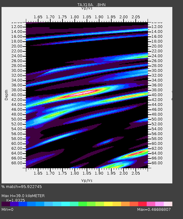
| Estimated Moho Depth: |
39.0 km |
| Estimated Crust Vp/Vs: |
1.83 |
| Assumed Crust Vp: |
6.496 km/s |
| Estimated Crust Vs: |
3.545 km/s |
| Estimated Crust Poisson's Ratio: |
0.29 |
|
| Radial Match: |
95.922745 % |
| Radial Bump: |
313 |
| Transverse Match: |
81.64748 % |
| Transverse Bump: |
400 |
| SOD ConfigId: |
2564 |
| Insert Time: |
2010-03-06 15:48:39.116 +0000 |
| GWidth: |
2.5 |
| Max Bumps: |
400 |
| Tol: |
0.001 |
|
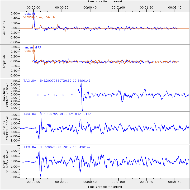
Signal To Noise
| Channel | StoN | STA | LTA |
| TA:X18A: :BHN:20070530T20:32:10.649014Z | 16.100426 | 1.3569464E-6 | 8.428016E-8 |
| TA:X18A: :BHE:20070530T20:32:10.649014Z | 20.392982 | 1.0012237E-6 | 4.909648E-8 |
| TA:X18A: :BHZ:20070530T20:32:10.649014Z | 49.61264 | 3.984607E-6 | 8.031435E-8 |
| Arrivals |
| Ps | 5.2 SECOND |
| PpPs | 16 SECOND |
| PsPs/PpSs | 22 SECOND |


