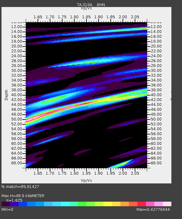
X18A Snowflake, AZ, USA - Earthquake Result Viewer
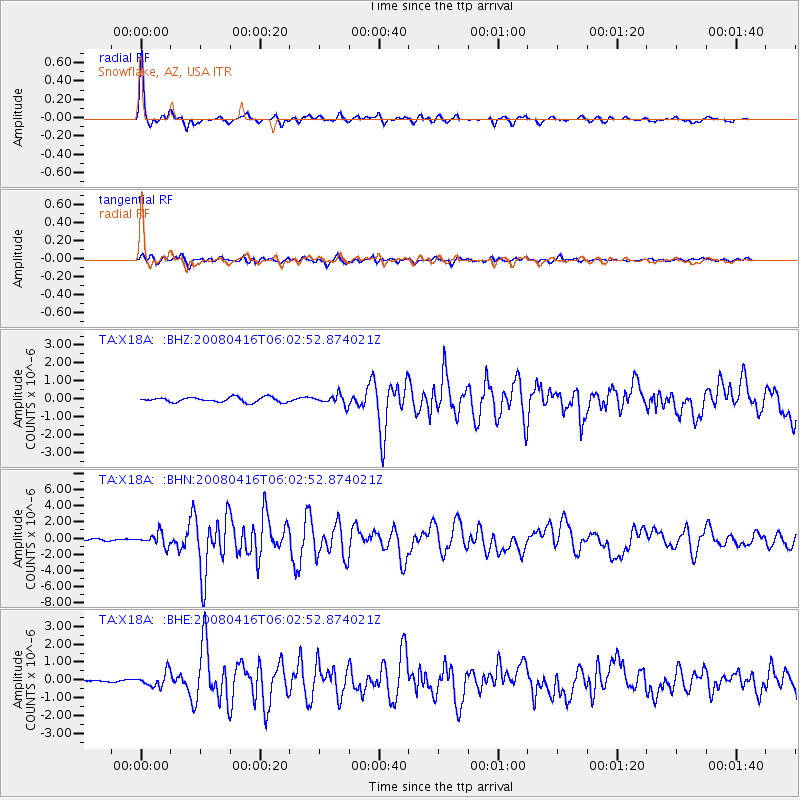
Earthquake location: Andreanof Islands, Aleutian Is.
Earthquake latitude/longitude: 51.9/-179.2
Earthquake time(UTC): 2008/04/16 (107) 05:54:19 GMT
Earthquake Depth: 13 km
Earthquake Magnitude: 6.1 MB, 6.5 MS, 6.6 MW, 6.6 MW
Earthquake Catalog/Contributor: WHDF/NEIC
Network: TA USArray Transportable Network (new EarthScope stations)
Station: X18A Snowflake, AZ, USA
Lat/Lon: 34.53 N/109.95 W
Elevation: 1751 m
Distance: 51.4 deg
Az: 81.172 deg
Baz: 312.102 deg
Ray Param: 0.06745353
Estimated Moho Depth: 49.5 km
Estimated Crust Vp/Vs: 1.62
Assumed Crust Vp: 6.496 km/s
Estimated Crust Vs: 3.998 km/s
Estimated Crust Poisson's Ratio: 0.20
Radial Match: 95.81427 %
Radial Bump: 291
Transverse Match: 81.97849 %
Transverse Bump: 400
SOD ConfigId: 2504
Insert Time: 2010-03-06 15:48:47.803 +0000
GWidth: 2.5
Max Bumps: 400
Tol: 0.001

Signal To Noise

ChannelStoNSTALTA
TA:X18A: :BHN:20080416T06:02:52.874021Z9.9637087.8861535E-77.914878E-8
TA:X18A: :BHE:20080416T06:02:52.874021Z4.40421724.05914E-79.216484E-8
TA:X18A: :BHZ:20080416T06:02:52.874021Z2.03565882.8133985E-71.3820579E-7
Arrivals
Ps5.1 SECOND
PpPs19 SECOND
PsPs/PpSs24 SECOND