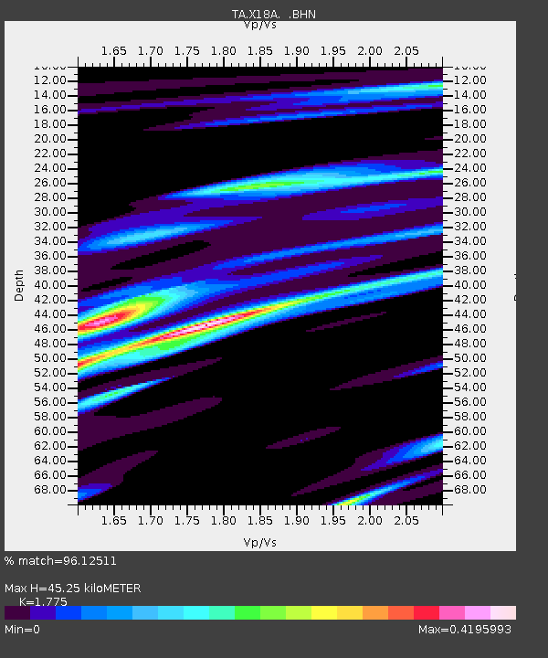
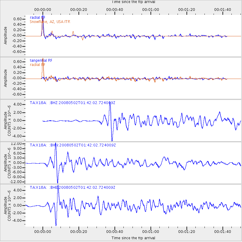
X18A Snowflake, AZ, USA - Earthquake Result Viewer

Earthquake location: Andreanof Islands, Aleutian Is.
Earthquake latitude/longitude: 51.9/-177.5
Earthquake time(UTC): 2008/05/02 (123) 01:33:37 GMT
Earthquake Depth: 14 km
Earthquake Magnitude: 6.3 MB, 6.8 MS, 6.6 MW, 6.6 MW
Earthquake Catalog/Contributor: WHDF/NEIC
Network: TA USArray Transportable Network (new EarthScope stations)
Station: X18A Snowflake, AZ, USA
Lat/Lon: 34.53 N/109.95 W
Elevation: 1751 m
Distance: 50.4 deg
Az: 82.326 deg
Baz: 311.897 deg
Ray Param: 0.06809833
Estimated Moho Depth: 45.25 km
Estimated Crust Vp/Vs: 1.77
Assumed Crust Vp: 6.496 km/s
Estimated Crust Vs: 3.66 km/s
Estimated Crust Poisson's Ratio: 0.27
Radial Match: 96.12511 %
Radial Bump: 296
Transverse Match: 87.434784 %
Transverse Bump: 377
SOD ConfigId: 2504
Insert Time: 2010-03-06 15:48:53.239 +0000
GWidth: 2.5
Max Bumps: 400
Tol: 0.001

Signal To Noise

ChannelStoNSTALTA
TA:X18A: :BHN:20080502T01:42:02.724009Z19.9854951.5805487E-67.908479E-8
TA:X18A: :BHE:20080502T01:42:02.724009Z3.7347626.393118E-71.7117873E-7
TA:X18A: :BHZ:20080502T01:42:02.724009Z6.683076.256806E-79.3621736E-8
Arrivals
Ps5.7 SECOND
PpPs18 SECOND
PsPs/PpSs24 SECOND