You are here: Home > Network List > TA - USArray Transportable Network (new EarthScope stations) Stations List
> Station X18A Snowflake, AZ, USA > Earthquake Result Viewer
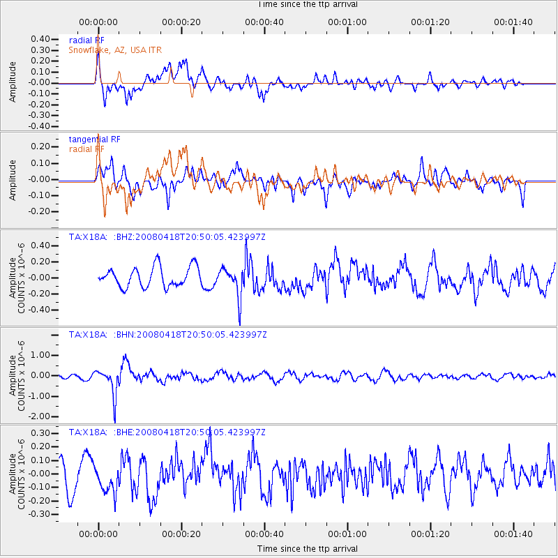
X18A Snowflake, AZ, USA - Earthquake Result Viewer
*The percent match for this event was below the threshold and hence no stack was calculated.
| Earthquake location: |
Fiji Islands Region |
| Earthquake latitude/longitude: |
-17.3/-179.0 |
| Earthquake time(UTC): |
2008/04/18 (109) 20:39:07 GMT |
| Earthquake Depth: |
554 km |
| Earthquake Magnitude: |
5.9 MB, 6.3 MW, 6.3 MW |
| Earthquake Catalog/Contributor: |
WHDF/NEIC |
|
| Network: |
TA USArray Transportable Network (new EarthScope stations) |
| Station: |
X18A Snowflake, AZ, USA |
| Lat/Lon: |
34.53 N/109.95 W |
| Elevation: |
1751 m |
|
| Distance: |
83.4 deg |
| Az: |
50.918 deg |
| Baz: |
243.897 deg |
| Ray Param: |
$rayparam |
*The percent match for this event was below the threshold and hence was not used in the summary stack. |
|
| Radial Match: |
74.26775 % |
| Radial Bump: |
400 |
| Transverse Match: |
68.63764 % |
| Transverse Bump: |
400 |
| SOD ConfigId: |
2504 |
| Insert Time: |
2010-03-06 15:49:11.707 +0000 |
| GWidth: |
2.5 |
| Max Bumps: |
400 |
| Tol: |
0.001 |
|
Signal To Noise
| Channel | StoN | STA | LTA |
| TA:X18A: :BHN:20080418T20:50:05.423997Z | 6.0782776 | 6.5865646E-7 | 1.0836236E-7 |
| TA:X18A: :BHE:20080418T20:50:05.423997Z | 0.8234615 | 8.948586E-8 | 1.0867036E-7 |
| TA:X18A: :BHZ:20080418T20:50:05.423997Z | 1.5391927 | 1.8791869E-7 | 1.2208912E-7 |
| Arrivals |
| Ps | |
| PpPs | |
| PsPs/PpSs | |


