You are here: Home > Network List > TA - USArray Transportable Network (new EarthScope stations) Stations List
> Station X18A Snowflake, AZ, USA > Earthquake Result Viewer
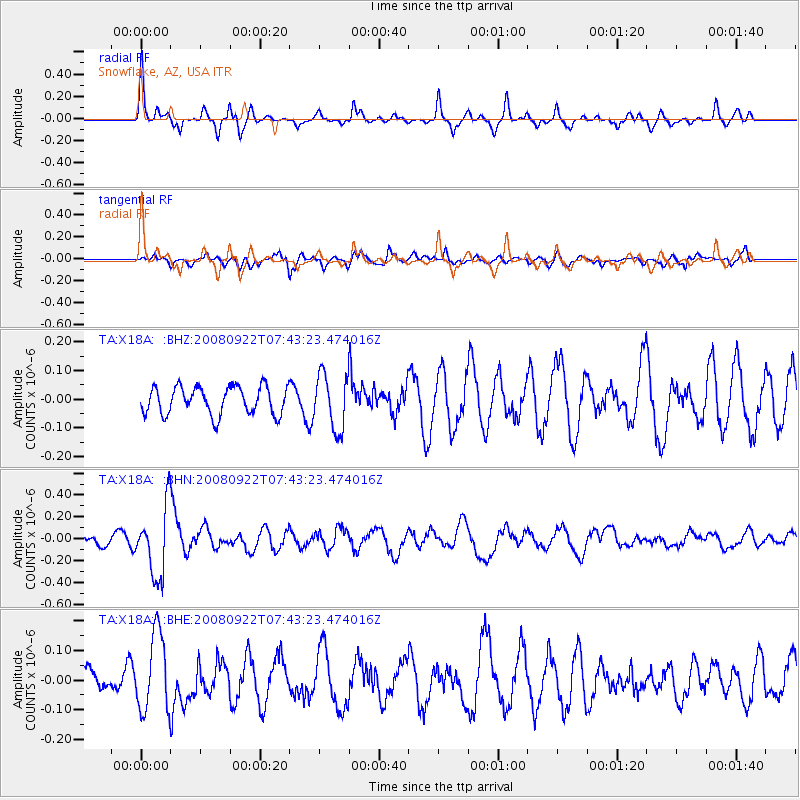
X18A Snowflake, AZ, USA - Earthquake Result Viewer
*The percent match for this event was below the threshold and hence no stack was calculated.
| Earthquake location: |
Hokkaido, Japan Region |
| Earthquake latitude/longitude: |
41.6/140.4 |
| Earthquake time(UTC): |
2008/09/22 (266) 07:31:59 GMT |
| Earthquake Depth: |
149 km |
| Earthquake Magnitude: |
5.7 MW, 5.3 MB, 5.6 MW |
| Earthquake Catalog/Contributor: |
WHDF/NEIC |
|
| Network: |
TA USArray Transportable Network (new EarthScope stations) |
| Station: |
X18A Snowflake, AZ, USA |
| Lat/Lon: |
34.53 N/109.95 W |
| Elevation: |
1751 m |
|
| Distance: |
80.5 deg |
| Az: |
52.056 deg |
| Baz: |
314.222 deg |
| Ray Param: |
$rayparam |
*The percent match for this event was below the threshold and hence was not used in the summary stack. |
|
| Radial Match: |
74.79884 % |
| Radial Bump: |
295 |
| Transverse Match: |
67.56629 % |
| Transverse Bump: |
400 |
| SOD ConfigId: |
2560 |
| Insert Time: |
2010-03-06 15:49:58.596 +0000 |
| GWidth: |
2.5 |
| Max Bumps: |
400 |
| Tol: |
0.001 |
|
Signal To Noise
| Channel | StoN | STA | LTA |
| TA:X18A: :BHN:20080922T07:43:23.474016Z | 4.4167957 | 3.1666312E-7 | 7.169522E-8 |
| TA:X18A: :BHE:20080922T07:43:23.474016Z | 1.6989547 | 1.3260647E-7 | 7.8051805E-8 |
| TA:X18A: :BHZ:20080922T07:43:23.474016Z | 1.9821153 | 9.5885476E-8 | 4.8375327E-8 |
| Arrivals |
| Ps | |
| PpPs | |
| PsPs/PpSs | |


