You are here: Home > Network List > TA - USArray Transportable Network (new EarthScope stations) Stations List
> Station X18A Snowflake, AZ, USA > Earthquake Result Viewer
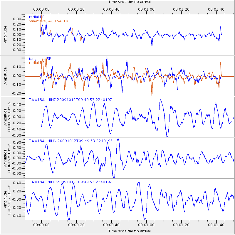
X18A Snowflake, AZ, USA - Earthquake Result Viewer
*The percent match for this event was below the threshold and hence no stack was calculated.
| Earthquake location: |
Santa Cruz Islands |
| Earthquake latitude/longitude: |
-12.4/166.5 |
| Earthquake time(UTC): |
2009/10/12 (285) 09:37:21 GMT |
| Earthquake Depth: |
42 km |
| Earthquake Magnitude: |
5.9 MB, 5.9 MS, 6.2 MW, 6.2 MW |
| Earthquake Catalog/Contributor: |
WHDF/NEIC |
|
| Network: |
TA USArray Transportable Network (new EarthScope stations) |
| Station: |
X18A Snowflake, AZ, USA |
| Lat/Lon: |
34.53 N/109.95 W |
| Elevation: |
1751 m |
|
| Distance: |
91.7 deg |
| Az: |
55.16 deg |
| Baz: |
256.21 deg |
| Ray Param: |
$rayparam |
*The percent match for this event was below the threshold and hence was not used in the summary stack. |
|
| Radial Match: |
59.859356 % |
| Radial Bump: |
400 |
| Transverse Match: |
71.143936 % |
| Transverse Bump: |
381 |
| SOD ConfigId: |
2622 |
| Insert Time: |
2010-03-06 15:50:19.562 +0000 |
| GWidth: |
2.5 |
| Max Bumps: |
400 |
| Tol: |
0.001 |
|
Signal To Noise
| Channel | StoN | STA | LTA |
| TA:X18A: :BHN:20091012T09:49:53.224019Z | 2.17476 | 4.1732977E-7 | 1.9189694E-7 |
| TA:X18A: :BHE:20091012T09:49:53.224019Z | 1.3582675 | 1.7725093E-7 | 1.304978E-7 |
| TA:X18A: :BHZ:20091012T09:49:53.224019Z | 1.8748496 | 3.0217655E-7 | 1.6117376E-7 |
| Arrivals |
| Ps | |
| PpPs | |
| PsPs/PpSs | |


