You are here: Home > Network List > TA - USArray Transportable Network (new EarthScope stations) Stations List
> Station X18A Snowflake, AZ, USA > Earthquake Result Viewer
X18A Snowflake, AZ, USA - Earthquake Result Viewer
*The percent match for this event was below the threshold and hence no stack was calculated.
| Earthquake location: |
Off East Coast Of Honshu, Japan |
| Earthquake latitude/longitude: |
36.5/142.4 |
| Earthquake time(UTC): |
2008/12/20 (355) 10:29:23 GMT |
| Earthquake Depth: |
19 km |
| Earthquake Magnitude: |
6.0 MB, 6.3 MS, 6.3 MW, 6.3 MW |
| Earthquake Catalog/Contributor: |
WHDF/NEIC |
|
| Network: |
TA USArray Transportable Network (new EarthScope stations) |
| Station: |
X18A Snowflake, AZ, USA |
| Lat/Lon: |
34.53 N/109.95 W |
| Elevation: |
1751 m |
|
| Distance: |
82.3 deg |
| Az: |
52.554 deg |
| Baz: |
309.246 deg |
| Ray Param: |
$rayparam |
*The percent match for this event was below the threshold and hence was not used in the summary stack. |
|
| Radial Match: |
77.368324 % |
| Radial Bump: |
297 |
| Transverse Match: |
64.26457 % |
| Transverse Bump: |
400 |
| SOD ConfigId: |
2658 |
| Insert Time: |
2010-03-06 15:50:52.621 +0000 |
| GWidth: |
2.5 |
| Max Bumps: |
400 |
| Tol: |
0.001 |
|
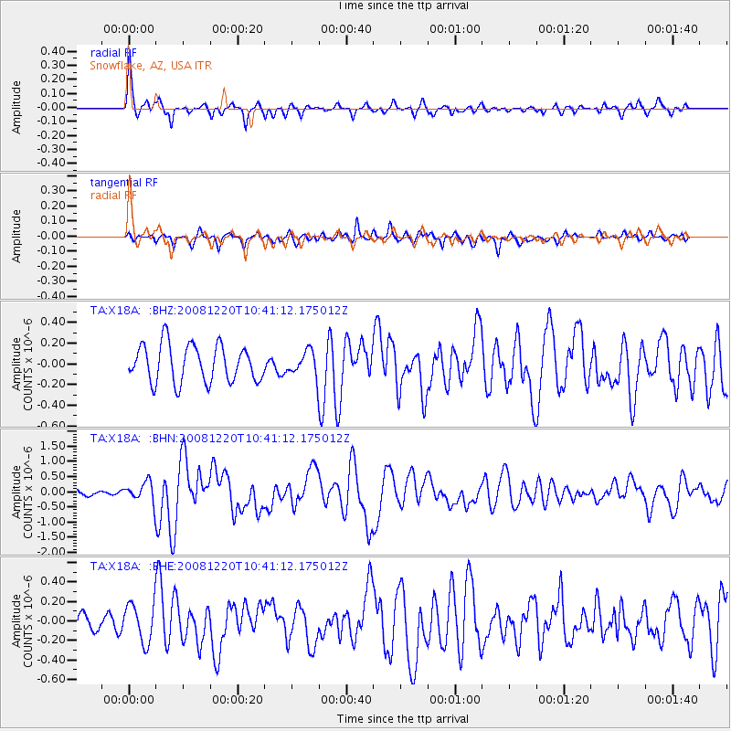
Signal To Noise
| Channel | StoN | STA | LTA |
| TA:X18A: :BHN:20081220T10:41:12.175012Z | 2.4846027 | 3.3370893E-7 | 1.3431078E-7 |
| TA:X18A: :BHE:20081220T10:41:12.175012Z | 2.4130971 | 2.0338403E-7 | 8.42834E-8 |
| TA:X18A: :BHZ:20081220T10:41:12.175012Z | 0.6806875 | 1.2217352E-7 | 1.794855E-7 |
| Arrivals |
| Ps | |
| PpPs | |
| PsPs/PpSs | |


