You are here: Home > Network List > TA - USArray Transportable Network (new EarthScope stations) Stations List
> Station G27K Doyon Strip, AK, USA > Earthquake Result Viewer
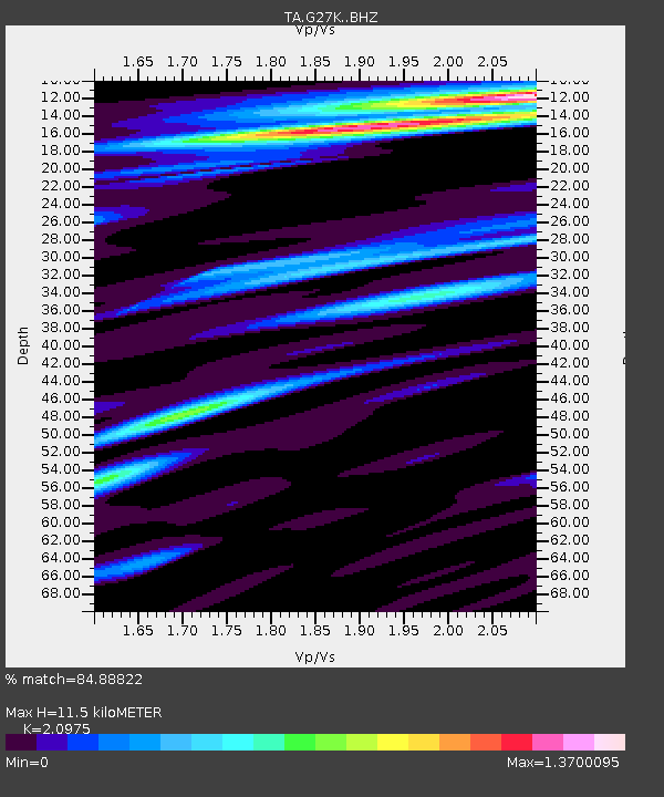
G27K Doyon Strip, AK, USA - Earthquake Result Viewer
| Earthquake location: |
Irian Jaya, Indonesia |
| Earthquake latitude/longitude: |
-2.8/138.8 |
| Earthquake time(UTC): |
2018/09/14 (257) 15:50:16 GMT |
| Earthquake Depth: |
33 km |
| Earthquake Magnitude: |
5.9 Mww |
| Earthquake Catalog/Contributor: |
NEIC PDE/us |
|
| Network: |
TA USArray Transportable Network (new EarthScope stations) |
| Station: |
G27K Doyon Strip, AK, USA |
| Lat/Lon: |
66.81 N/141.65 W |
| Elevation: |
686 m |
|
| Distance: |
88.4 deg |
| Az: |
22.934 deg |
| Baz: |
259.354 deg |
| Ray Param: |
0.04255982 |
| Estimated Moho Depth: |
11.5 km |
| Estimated Crust Vp/Vs: |
2.10 |
| Assumed Crust Vp: |
6.577 km/s |
| Estimated Crust Vs: |
3.136 km/s |
| Estimated Crust Poisson's Ratio: |
0.35 |
|
| Radial Match: |
84.88822 % |
| Radial Bump: |
400 |
| Transverse Match: |
74.974556 % |
| Transverse Bump: |
400 |
| SOD ConfigId: |
13570011 |
| Insert Time: |
2019-05-01 05:57:09.843 +0000 |
| GWidth: |
2.5 |
| Max Bumps: |
400 |
| Tol: |
0.001 |
|

Signal To Noise
| Channel | StoN | STA | LTA |
| TA:G27K: :BHZ:20180914T16:02:33.450015Z | 6.5805545 | 5.352492E-7 | 8.1338015E-8 |
| TA:G27K: :BHN:20180914T16:02:33.450015Z | 1.3544645 | 9.193259E-8 | 6.787375E-8 |
| TA:G27K: :BHE:20180914T16:02:33.450015Z | 4.738739 | 2.847956E-7 | 6.0099445E-8 |
| Arrivals |
| Ps | 2.0 SECOND |
| PpPs | 5.3 SECOND |
| PsPs/PpSs | 7.3 SECOND |


