You are here: Home > Network List > TA - USArray Transportable Network (new EarthScope stations) Stations List
> Station J26L Joseph Creek, AK, USA > Earthquake Result Viewer
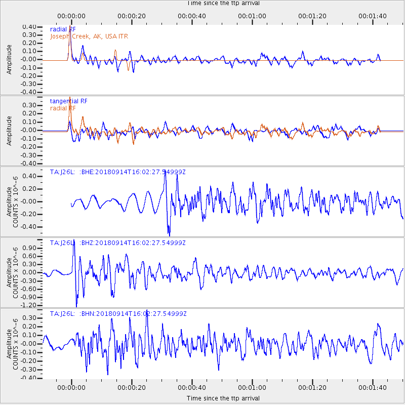
J26L Joseph Creek, AK, USA - Earthquake Result Viewer
*The percent match for this event was below the threshold and hence no stack was calculated.
| Earthquake location: |
Irian Jaya, Indonesia |
| Earthquake latitude/longitude: |
-2.8/138.8 |
| Earthquake time(UTC): |
2018/09/14 (257) 15:50:16 GMT |
| Earthquake Depth: |
33 km |
| Earthquake Magnitude: |
5.9 Mww |
| Earthquake Catalog/Contributor: |
NEIC PDE/us |
|
| Network: |
TA USArray Transportable Network (new EarthScope stations) |
| Station: |
J26L Joseph Creek, AK, USA |
| Lat/Lon: |
64.50 N/143.56 W |
| Elevation: |
1144 m |
|
| Distance: |
87.2 deg |
| Az: |
25.049 deg |
| Baz: |
257.698 deg |
| Ray Param: |
$rayparam |
*The percent match for this event was below the threshold and hence was not used in the summary stack. |
|
| Radial Match: |
67.94827 % |
| Radial Bump: |
400 |
| Transverse Match: |
72.63583 % |
| Transverse Bump: |
400 |
| SOD ConfigId: |
13570011 |
| Insert Time: |
2019-05-01 05:57:37.089 +0000 |
| GWidth: |
2.5 |
| Max Bumps: |
400 |
| Tol: |
0.001 |
|
Signal To Noise
| Channel | StoN | STA | LTA |
| TA:J26L: :BHZ:20180914T16:02:27.54999Z | 7.831047 | 5.9916124E-7 | 7.6511E-8 |
| TA:J26L: :BHN:20180914T16:02:27.54999Z | 1.4153472 | 7.955828E-8 | 5.6211146E-8 |
| TA:J26L: :BHE:20180914T16:02:27.54999Z | 3.663521 | 2.8205915E-7 | 7.699127E-8 |
| Arrivals |
| Ps | |
| PpPs | |
| PsPs/PpSs | |


