You are here: Home > Network List > TA - USArray Transportable Network (new EarthScope stations) Stations List
> Station M31M Drury Creek, Yukon, CA > Earthquake Result Viewer
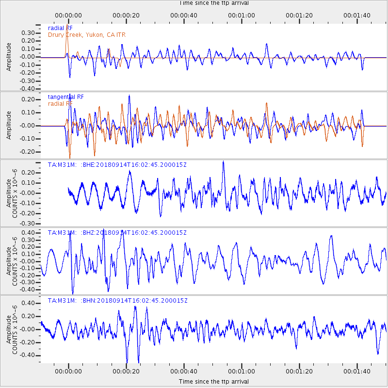
M31M Drury Creek, Yukon, CA - Earthquake Result Viewer
*The percent match for this event was below the threshold and hence no stack was calculated.
| Earthquake location: |
Irian Jaya, Indonesia |
| Earthquake latitude/longitude: |
-2.8/138.8 |
| Earthquake time(UTC): |
2018/09/14 (257) 15:50:16 GMT |
| Earthquake Depth: |
33 km |
| Earthquake Magnitude: |
5.9 Mww |
| Earthquake Catalog/Contributor: |
NEIC PDE/us |
|
| Network: |
TA USArray Transportable Network (new EarthScope stations) |
| Station: |
M31M Drury Creek, Yukon, CA |
| Lat/Lon: |
62.20 N/134.39 W |
| Elevation: |
639 m |
|
| Distance: |
90.9 deg |
| Az: |
27.915 deg |
| Baz: |
265.938 deg |
| Ray Param: |
$rayparam |
*The percent match for this event was below the threshold and hence was not used in the summary stack. |
|
| Radial Match: |
52.548645 % |
| Radial Bump: |
400 |
| Transverse Match: |
47.262566 % |
| Transverse Bump: |
400 |
| SOD ConfigId: |
13570011 |
| Insert Time: |
2019-05-01 05:58:02.897 +0000 |
| GWidth: |
2.5 |
| Max Bumps: |
400 |
| Tol: |
0.001 |
|
Signal To Noise
| Channel | StoN | STA | LTA |
| TA:M31M: :BHZ:20180914T16:02:45.200015Z | 2.276112 | 2.2230941E-7 | 9.767067E-8 |
| TA:M31M: :BHN:20180914T16:02:45.200015Z | 0.8039221 | 7.90257E-8 | 9.83002E-8 |
| TA:M31M: :BHE:20180914T16:02:45.200015Z | 1.0227835 | 9.041713E-8 | 8.8403E-8 |
| Arrivals |
| Ps | |
| PpPs | |
| PsPs/PpSs | |


