You are here: Home > Network List > TA - USArray Transportable Network (new EarthScope stations) Stations List
> Station O16K Kokwok River, Bristol Bay, AK, USA > Earthquake Result Viewer
O16K Kokwok River, Bristol Bay, AK, USA - Earthquake Result Viewer
| Earthquake location: |
Irian Jaya, Indonesia |
| Earthquake latitude/longitude: |
-2.8/138.8 |
| Earthquake time(UTC): |
2018/09/14 (257) 15:50:16 GMT |
| Earthquake Depth: |
33 km |
| Earthquake Magnitude: |
5.9 Mww |
| Earthquake Catalog/Contributor: |
NEIC PDE/us |
|
| Network: |
TA USArray Transportable Network (new EarthScope stations) |
| Station: |
O16K Kokwok River, Bristol Bay, AK, USA |
| Lat/Lon: |
59.59 N/158.09 W |
| Elevation: |
198 m |
|
| Distance: |
79.1 deg |
| Az: |
27.522 deg |
| Baz: |
245.151 deg |
| Ray Param: |
0.049116973 |
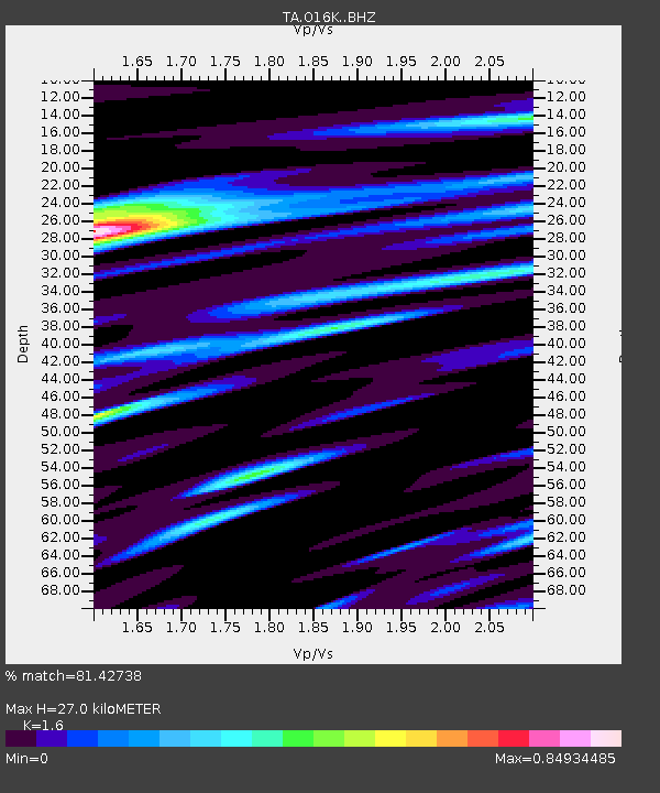
| Estimated Moho Depth: |
27.0 km |
| Estimated Crust Vp/Vs: |
1.60 |
| Assumed Crust Vp: |
6.24 km/s |
| Estimated Crust Vs: |
3.9 km/s |
| Estimated Crust Poisson's Ratio: |
0.18 |
|
| Radial Match: |
81.42738 % |
| Radial Bump: |
330 |
| Transverse Match: |
64.4391 % |
| Transverse Bump: |
400 |
| SOD ConfigId: |
13570011 |
| Insert Time: |
2019-05-01 05:58:16.359 +0000 |
| GWidth: |
2.5 |
| Max Bumps: |
400 |
| Tol: |
0.001 |
|

Signal To Noise
| Channel | StoN | STA | LTA |
| TA:O16K: :BHZ:20180914T16:01:46.275027Z | 11.478005 | 6.6577616E-7 | 5.8004517E-8 |
| TA:O16K: :BHN:20180914T16:01:46.275027Z | 1.856689 | 1.880863E-7 | 1.0130199E-7 |
| TA:O16K: :BHE:20180914T16:01:46.275027Z | 2.6139288 | 2.1142846E-7 | 8.088532E-8 |
| Arrivals |
| Ps | 2.7 SECOND |
| PpPs | 11 SECOND |
| PsPs/PpSs | 14 SECOND |


