You are here: Home > Network List > CI - Caltech Regional Seismic Network Stations List
> Station MPM Manuel Prospect Mine, California, USA > Earthquake Result Viewer
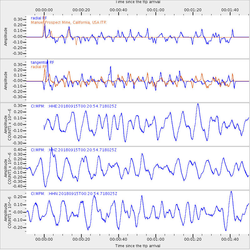
MPM Manuel Prospect Mine, California, USA - Earthquake Result Viewer
*The percent match for this event was below the threshold and hence no stack was calculated.
| Earthquake location: |
Ryukyu Islands, Japan |
| Earthquake latitude/longitude: |
26.7/129.6 |
| Earthquake time(UTC): |
2018/09/15 (258) 00:08:20 GMT |
| Earthquake Depth: |
5.9 km |
| Earthquake Magnitude: |
5.6 Mww |
| Earthquake Catalog/Contributor: |
NEIC PDE/us |
|
| Network: |
CI Caltech Regional Seismic Network |
| Station: |
MPM Manuel Prospect Mine, California, USA |
| Lat/Lon: |
36.06 N/117.49 W |
| Elevation: |
185 m |
|
| Distance: |
91.1 deg |
| Az: |
48.311 deg |
| Baz: |
304.497 deg |
| Ray Param: |
$rayparam |
*The percent match for this event was below the threshold and hence was not used in the summary stack. |
|
| Radial Match: |
54.407387 % |
| Radial Bump: |
369 |
| Transverse Match: |
64.62869 % |
| Transverse Bump: |
347 |
| SOD ConfigId: |
13570011 |
| Insert Time: |
2019-05-01 06:02:32.002 +0000 |
| GWidth: |
2.5 |
| Max Bumps: |
400 |
| Tol: |
0.001 |
|
Signal To Noise
| Channel | StoN | STA | LTA |
| CI:MPM: :HHZ:20180915T00:20:54.718025Z | 3.8109257 | 2.850068E-7 | 7.478676E-8 |
| CI:MPM: :HHN:20180915T00:20:54.718025Z | 1.1120955 | 8.0931734E-8 | 7.2774085E-8 |
| CI:MPM: :HHE:20180915T00:20:54.718025Z | 0.8748245 | 1.0383117E-7 | 1.1868799E-7 |
| Arrivals |
| Ps | |
| PpPs | |
| PsPs/PpSs | |


