You are here: Home > Network List > TA - USArray Transportable Network (new EarthScope stations) Stations List
> Station E13A Victor, MT, USA > Earthquake Result Viewer
E13A Victor, MT, USA - Earthquake Result Viewer
| Earthquake location: |
Vanuatu Islands |
| Earthquake latitude/longitude: |
-13.5/167.0 |
| Earthquake time(UTC): |
2008/09/08 (252) 18:52:06 GMT |
| Earthquake Depth: |
110 km |
| Earthquake Magnitude: |
6.4 MB, 6.9 MW, 6.9 MW |
| Earthquake Catalog/Contributor: |
WHDF/NEIC |
|
| Network: |
TA USArray Transportable Network (new EarthScope stations) |
| Station: |
E13A Victor, MT, USA |
| Lat/Lon: |
46.44 N/114.19 W |
| Elevation: |
1257 m |
|
| Distance: |
92.1 deg |
| Az: |
42.76 deg |
| Baz: |
252.748 deg |
| Ray Param: |
0.041455936 |
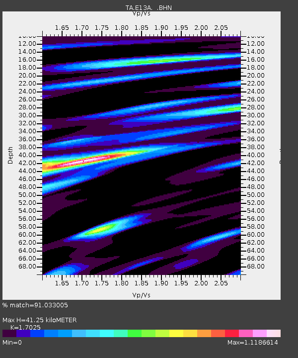
| Estimated Moho Depth: |
41.25 km |
| Estimated Crust Vp/Vs: |
1.70 |
| Assumed Crust Vp: |
6.622 km/s |
| Estimated Crust Vs: |
3.89 km/s |
| Estimated Crust Poisson's Ratio: |
0.24 |
|
| Radial Match: |
91.033005 % |
| Radial Bump: |
400 |
| Transverse Match: |
80.96823 % |
| Transverse Bump: |
400 |
| SOD ConfigId: |
2560 |
| Insert Time: |
2010-03-06 15:51:59.462 +0000 |
| GWidth: |
2.5 |
| Max Bumps: |
400 |
| Tol: |
0.001 |
|

Signal To Noise
| Channel | StoN | STA | LTA |
| TA:E13A: :BHN:20080908T19:04:32.774016Z | 25.767853 | 2.7101291E-6 | 1.0517481E-7 |
| TA:E13A: :BHE:20080908T19:04:32.774016Z | 5.335182 | 3.5028793E-7 | 6.5656224E-8 |
| TA:E13A: :BHZ:20080908T19:04:32.774016Z | 10.495642 | 9.4709435E-7 | 9.0236924E-8 |
| Arrivals |
| Ps | 4.5 SECOND |
| PpPs | 16 SECOND |
| PsPs/PpSs | 21 SECOND |


