You are here: Home > Network List > TA - USArray Transportable Network (new EarthScope stations) Stations List
> Station E13A Victor, MT, USA > Earthquake Result Viewer
E13A Victor, MT, USA - Earthquake Result Viewer
| Earthquake location: |
Southern Greece |
| Earthquake latitude/longitude: |
37.2/22.7 |
| Earthquake time(UTC): |
2008/01/06 (006) 05:14:20 GMT |
| Earthquake Depth: |
75 km |
| Earthquake Magnitude: |
6.1 MB, 6.2 MW, 6.1 MW |
| Earthquake Catalog/Contributor: |
WHDF/NEIC |
|
| Network: |
TA USArray Transportable Network (new EarthScope stations) |
| Station: |
E13A Victor, MT, USA |
| Lat/Lon: |
46.44 N/114.19 W |
| Elevation: |
1257 m |
|
| Distance: |
88.2 deg |
| Az: |
331.777 deg |
| Baz: |
33.089 deg |
| Ray Param: |
0.042646445 |
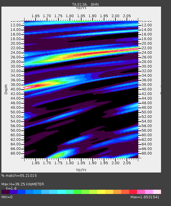
| Estimated Moho Depth: |
39.25 km |
| Estimated Crust Vp/Vs: |
1.60 |
| Assumed Crust Vp: |
6.622 km/s |
| Estimated Crust Vs: |
4.139 km/s |
| Estimated Crust Poisson's Ratio: |
0.18 |
|
| Radial Match: |
85.21015 % |
| Radial Bump: |
400 |
| Transverse Match: |
68.90436 % |
| Transverse Bump: |
400 |
| SOD ConfigId: |
2564 |
| Insert Time: |
2010-03-06 15:52:10.859 +0000 |
| GWidth: |
2.5 |
| Max Bumps: |
400 |
| Tol: |
0.001 |
|

Signal To Noise
| Channel | StoN | STA | LTA |
| TA:E13A: :BHN:20080106T05:26:31.57502Z | 1.9214865 | 6.166805E-7 | 3.2093928E-7 |
| TA:E13A: :BHE:20080106T05:26:31.57502Z | 0.8392998 | 3.97328E-7 | 4.7340413E-7 |
| TA:E13A: :BHZ:20080106T05:26:31.57502Z | 4.0116963 | 2.0341467E-6 | 5.0705404E-7 |
| Arrivals |
| Ps | 3.6 SECOND |
| PpPs | 15 SECOND |
| PsPs/PpSs | 19 SECOND |


