You are here: Home > Network List > TA - USArray Transportable Network (new EarthScope stations) Stations List
> Station A36M Sachs Harbour, NT, CAN > Earthquake Result Viewer
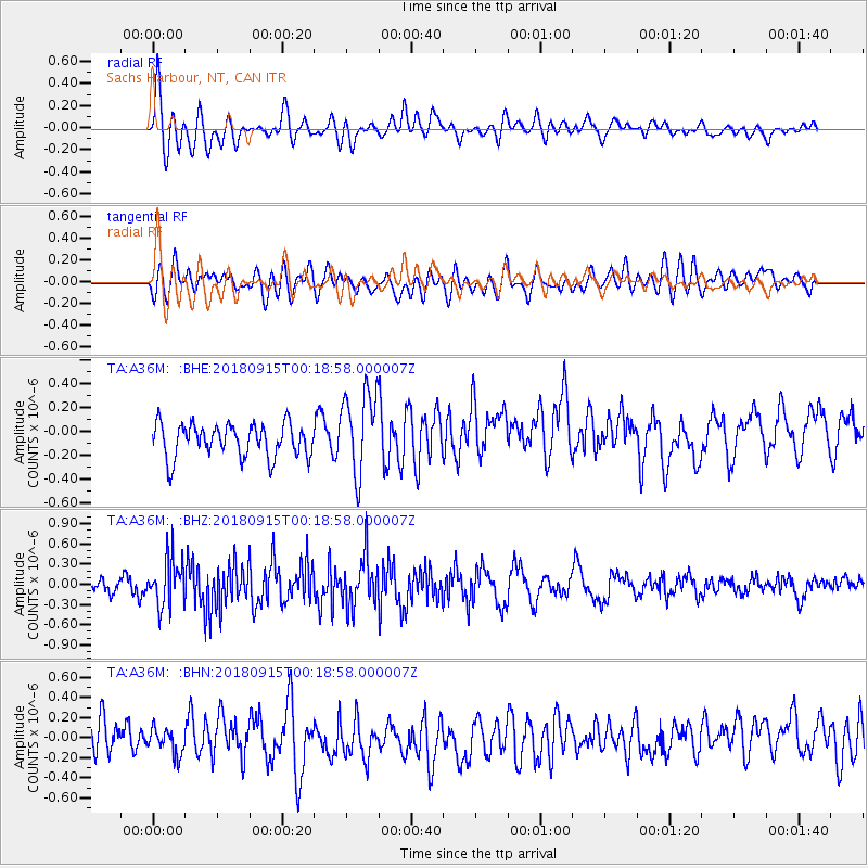
A36M Sachs Harbour, NT, CAN - Earthquake Result Viewer
*The percent match for this event was below the threshold and hence no stack was calculated.
| Earthquake location: |
Ryukyu Islands, Japan |
| Earthquake latitude/longitude: |
26.7/129.6 |
| Earthquake time(UTC): |
2018/09/15 (258) 00:08:20 GMT |
| Earthquake Depth: |
5.9 km |
| Earthquake Magnitude: |
5.6 Mww |
| Earthquake Catalog/Contributor: |
NEIC PDE/us |
|
| Network: |
TA USArray Transportable Network (new EarthScope stations) |
| Station: |
A36M Sachs Harbour, NT, CAN |
| Lat/Lon: |
71.99 N/125.25 W |
| Elevation: |
32 m |
|
| Distance: |
69.3 deg |
| Az: |
18.724 deg |
| Baz: |
292.675 deg |
| Ray Param: |
$rayparam |
*The percent match for this event was below the threshold and hence was not used in the summary stack. |
|
| Radial Match: |
62.294792 % |
| Radial Bump: |
400 |
| Transverse Match: |
41.919727 % |
| Transverse Bump: |
400 |
| SOD ConfigId: |
13570011 |
| Insert Time: |
2019-05-01 06:06:16.157 +0000 |
| GWidth: |
2.5 |
| Max Bumps: |
400 |
| Tol: |
0.001 |
|
Signal To Noise
| Channel | StoN | STA | LTA |
| TA:A36M: :BHZ:20180915T00:18:58.000007Z | 2.8740644 | 3.548286E-7 | 1.2345882E-7 |
| TA:A36M: :BHN:20180915T00:18:58.000007Z | 0.57275265 | 1.2518825E-7 | 2.1857299E-7 |
| TA:A36M: :BHE:20180915T00:18:58.000007Z | 2.550259 | 3.516585E-7 | 1.3789128E-7 |
| Arrivals |
| Ps | |
| PpPs | |
| PsPs/PpSs | |


