You are here: Home > Network List > TA - USArray Transportable Network (new EarthScope stations) Stations List
> Station E18K Tukpahlearik Creek, AK, USA > Earthquake Result Viewer
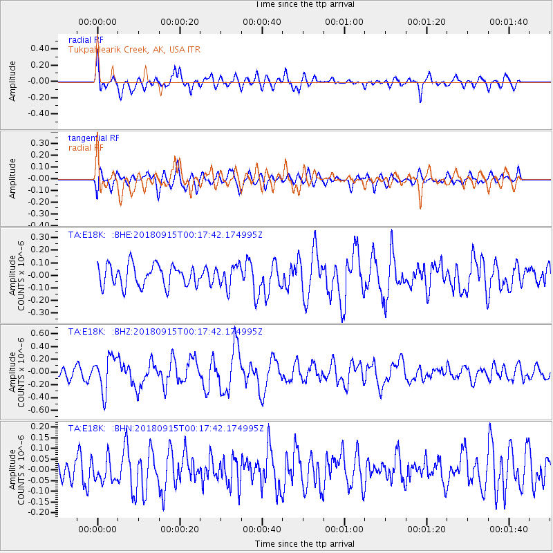
E18K Tukpahlearik Creek, AK, USA - Earthquake Result Viewer
*The percent match for this event was below the threshold and hence no stack was calculated.
| Earthquake location: |
Ryukyu Islands, Japan |
| Earthquake latitude/longitude: |
26.7/129.6 |
| Earthquake time(UTC): |
2018/09/15 (258) 00:08:20 GMT |
| Earthquake Depth: |
5.9 km |
| Earthquake Magnitude: |
5.6 Mww |
| Earthquake Catalog/Contributor: |
NEIC PDE/us |
|
| Network: |
TA USArray Transportable Network (new EarthScope stations) |
| Station: |
E18K Tukpahlearik Creek, AK, USA |
| Lat/Lon: |
67.42 N/160.60 W |
| Elevation: |
297 m |
|
| Distance: |
57.8 deg |
| Az: |
25.339 deg |
| Baz: |
262.35 deg |
| Ray Param: |
$rayparam |
*The percent match for this event was below the threshold and hence was not used in the summary stack. |
|
| Radial Match: |
70.65077 % |
| Radial Bump: |
400 |
| Transverse Match: |
54.905056 % |
| Transverse Bump: |
400 |
| SOD ConfigId: |
13570011 |
| Insert Time: |
2019-05-01 06:06:26.304 +0000 |
| GWidth: |
2.5 |
| Max Bumps: |
400 |
| Tol: |
0.001 |
|
Signal To Noise
| Channel | StoN | STA | LTA |
| TA:E18K: :BHZ:20180915T00:17:42.174995Z | 2.7598827 | 2.7814173E-7 | 1.0078027E-7 |
| TA:E18K: :BHN:20180915T00:17:42.174995Z | 0.6356823 | 5.409544E-8 | 8.5098236E-8 |
| TA:E18K: :BHE:20180915T00:17:42.174995Z | 1.0461946 | 8.82799E-8 | 8.438192E-8 |
| Arrivals |
| Ps | |
| PpPs | |
| PsPs/PpSs | |


