You are here: Home > Network List > TA - USArray Transportable Network (new EarthScope stations) Stations List
> Station F26K Sheenjek River, AK, USA > Earthquake Result Viewer
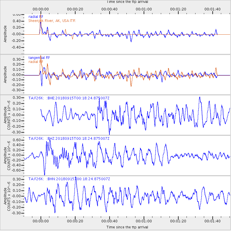
F26K Sheenjek River, AK, USA - Earthquake Result Viewer
*The percent match for this event was below the threshold and hence no stack was calculated.
| Earthquake location: |
Ryukyu Islands, Japan |
| Earthquake latitude/longitude: |
26.7/129.6 |
| Earthquake time(UTC): |
2018/09/15 (258) 00:08:20 GMT |
| Earthquake Depth: |
5.9 km |
| Earthquake Magnitude: |
5.6 Mww |
| Earthquake Catalog/Contributor: |
NEIC PDE/us |
|
| Network: |
TA USArray Transportable Network (new EarthScope stations) |
| Station: |
F26K Sheenjek River, AK, USA |
| Lat/Lon: |
67.69 N/144.15 W |
| Elevation: |
683 m |
|
| Distance: |
64.1 deg |
| Az: |
25.043 deg |
| Baz: |
277.417 deg |
| Ray Param: |
$rayparam |
*The percent match for this event was below the threshold and hence was not used in the summary stack. |
|
| Radial Match: |
73.18418 % |
| Radial Bump: |
400 |
| Transverse Match: |
55.321625 % |
| Transverse Bump: |
400 |
| SOD ConfigId: |
13570011 |
| Insert Time: |
2019-05-01 06:06:41.634 +0000 |
| GWidth: |
2.5 |
| Max Bumps: |
400 |
| Tol: |
0.001 |
|
Signal To Noise
| Channel | StoN | STA | LTA |
| TA:F26K: :BHZ:20180915T00:18:24.875007Z | 3.8564918 | 3.3348925E-7 | 8.647477E-8 |
| TA:F26K: :BHN:20180915T00:18:24.875007Z | 0.70203245 | 7.099816E-8 | 1.0113231E-7 |
| TA:F26K: :BHE:20180915T00:18:24.875007Z | 1.3931642 | 1.16586556E-7 | 8.3684725E-8 |
| Arrivals |
| Ps | |
| PpPs | |
| PsPs/PpSs | |


