You are here: Home > Network List > TA - USArray Transportable Network (new EarthScope stations) Stations List
> Station J20K Nowitna River, AK, USA > Earthquake Result Viewer
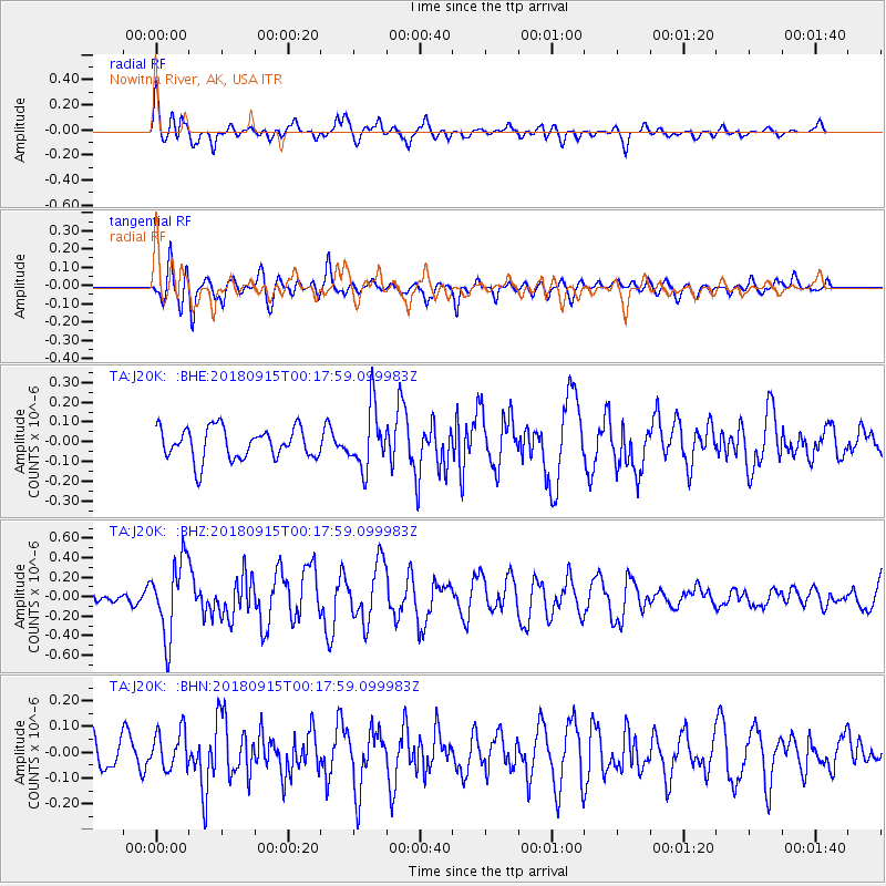
J20K Nowitna River, AK, USA - Earthquake Result Viewer
*The percent match for this event was below the threshold and hence no stack was calculated.
| Earthquake location: |
Ryukyu Islands, Japan |
| Earthquake latitude/longitude: |
26.7/129.6 |
| Earthquake time(UTC): |
2018/09/15 (258) 00:08:20 GMT |
| Earthquake Depth: |
5.9 km |
| Earthquake Magnitude: |
5.6 Mww |
| Earthquake Catalog/Contributor: |
NEIC PDE/us |
|
| Network: |
TA USArray Transportable Network (new EarthScope stations) |
| Station: |
J20K Nowitna River, AK, USA |
| Lat/Lon: |
64.18 N/154.15 W |
| Elevation: |
314 m |
|
| Distance: |
60.3 deg |
| Az: |
29.324 deg |
| Baz: |
270.285 deg |
| Ray Param: |
$rayparam |
*The percent match for this event was below the threshold and hence was not used in the summary stack. |
|
| Radial Match: |
64.24145 % |
| Radial Bump: |
400 |
| Transverse Match: |
62.394207 % |
| Transverse Bump: |
400 |
| SOD ConfigId: |
13570011 |
| Insert Time: |
2019-05-01 06:07:11.832 +0000 |
| GWidth: |
2.5 |
| Max Bumps: |
400 |
| Tol: |
0.001 |
|
Signal To Noise
| Channel | StoN | STA | LTA |
| TA:J20K: :BHZ:20180915T00:17:59.099983Z | 4.6271553 | 3.8256076E-7 | 8.267731E-8 |
| TA:J20K: :BHN:20180915T00:17:59.099983Z | 1.0394053 | 7.521692E-8 | 7.236534E-8 |
| TA:J20K: :BHE:20180915T00:17:59.099983Z | 1.9555506 | 1.5436093E-7 | 7.8934775E-8 |
| Arrivals |
| Ps | |
| PpPs | |
| PsPs/PpSs | |


