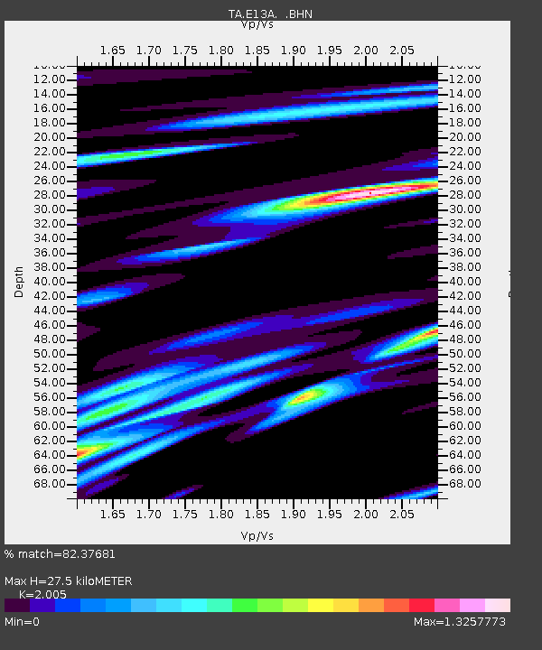
E13A Victor, MT, USA - Earthquake Result Viewer

Earthquake location: Andreanof Islands, Aleutian Is.
Earthquake latitude/longitude: 51.3/-180.0
Earthquake time(UTC): 2007/08/02 (214) 03:21:42 GMT
Earthquake Depth: 21 km
Earthquake Magnitude: 6.3 MB, 6.6 MS, 6.7 MW, 6.6 MW
Earthquake Catalog/Contributor: WHDF/NEIC
Network: TA USArray Transportable Network (new EarthScope stations)
Station: E13A Victor, MT, USA
Lat/Lon: 46.44 N/114.19 W
Elevation: 1257 m
Distance: 42.2 deg
Az: 69.753 deg
Baz: 301.61 deg
Ray Param: 0.073263355
Estimated Moho Depth: 27.5 km
Estimated Crust Vp/Vs: 2.01
Assumed Crust Vp: 6.622 km/s
Estimated Crust Vs: 3.303 km/s
Estimated Crust Poisson's Ratio: 0.33
Radial Match: 82.37681 %
Radial Bump: 400
Transverse Match: 76.781075 %
Transverse Bump: 400
SOD ConfigId: 2564
Insert Time: 2010-03-06 15:52:58.539 +0000
GWidth: 2.5
Max Bumps: 400
Tol: 0.001

Signal To Noise

ChannelStoNSTALTA
TA:E13A: :BHN:20070802T03:29:03.623009Z2.19692781.312737E-65.975331E-7
TA:E13A: :BHE:20070802T03:29:03.623009Z4.1072932.074827E-65.051568E-7
TA:E13A: :BHZ:20070802T03:29:03.623009Z5.82294463.218396E-65.527093E-7
Arrivals
Ps4.4 SECOND
PpPs12 SECOND
PsPs/PpSs16 SECOND