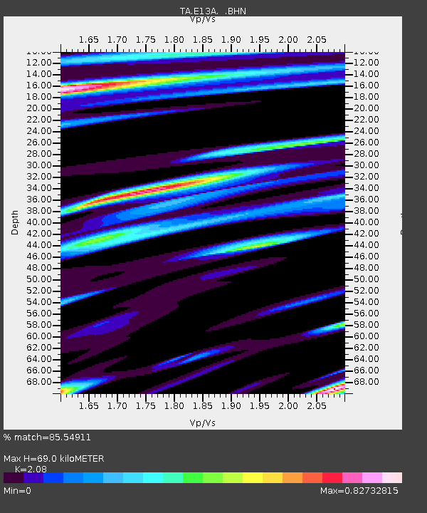
E13A Victor, MT, USA - Earthquake Result Viewer
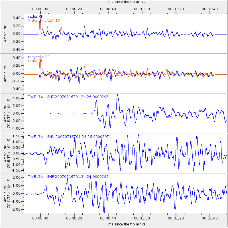
Earthquake location: Near West Coast Of Honshu, Japan
Earthquake latitude/longitude: 37.5/138.4
Earthquake time(UTC): 2007/07/16 (197) 01:13:22 GMT
Earthquake Depth: 12 km
Earthquake Magnitude: 6.5 MB, 6.4 MS, 6.6 MW, 6.5 MW
Earthquake Catalog/Contributor: WHDF/NEIC
Network: TA USArray Transportable Network (new EarthScope stations)
Station: E13A Victor, MT, USA
Lat/Lon: 46.44 N/114.19 W
Elevation: 1257 m
Distance: 74.1 deg
Az: 43.337 deg
Baz: 307.913 deg
Ray Param: 0.052564953
Estimated Moho Depth: 69.0 km
Estimated Crust Vp/Vs: 2.08
Assumed Crust Vp: 6.622 km/s
Estimated Crust Vs: 3.184 km/s
Estimated Crust Poisson's Ratio: 0.35
Radial Match: 85.54911 %
Radial Bump: 400
Transverse Match: 79.316185 %
Transverse Bump: 400
SOD ConfigId: 2564
Insert Time: 2010-03-06 15:53:11.571 +0000
GWidth: 2.5
Max Bumps: 400
Tol: 0.001

Signal To Noise

ChannelStoNSTALTA
TA:E13A: :BHN:20070716T01:24:26.900029Z9.6955383.5306013E-73.6414704E-8
TA:E13A: :BHE:20070716T01:24:26.900029Z8.0941564.8676435E-76.013776E-8
TA:E13A: :BHZ:20070716T01:24:26.900029Z41.9423871.5078862E-63.595137E-8
Arrivals
Ps12 SECOND
PpPs31 SECOND
PsPs/PpSs43 SECOND