You are here: Home > Network List > TA - USArray Transportable Network (new EarthScope stations) Stations List
> Station E13A Victor, MT, USA > Earthquake Result Viewer
E13A Victor, MT, USA - Earthquake Result Viewer
| Earthquake location: |
Costa Rica |
| Earthquake latitude/longitude: |
8.5/-83.2 |
| Earthquake time(UTC): |
2009/03/11 (070) 17:24:36 GMT |
| Earthquake Depth: |
14 km |
| Earthquake Magnitude: |
5.8 MB, 5.6 MS, 5.9 MW, 5.9 MW |
| Earthquake Catalog/Contributor: |
WHDF/NEIC |
|
| Network: |
TA USArray Transportable Network (new EarthScope stations) |
| Station: |
E13A Victor, MT, USA |
| Lat/Lon: |
46.44 N/114.19 W |
| Elevation: |
1257 m |
|
| Distance: |
46.2 deg |
| Az: |
330.441 deg |
| Baz: |
135.117 deg |
| Ray Param: |
0.07080526 |
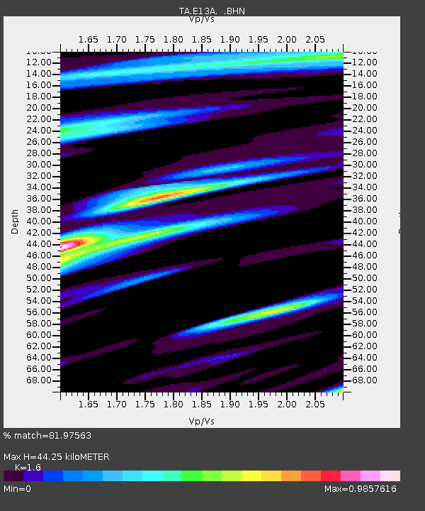
| Estimated Moho Depth: |
44.25 km |
| Estimated Crust Vp/Vs: |
1.60 |
| Assumed Crust Vp: |
6.622 km/s |
| Estimated Crust Vs: |
4.139 km/s |
| Estimated Crust Poisson's Ratio: |
0.18 |
|
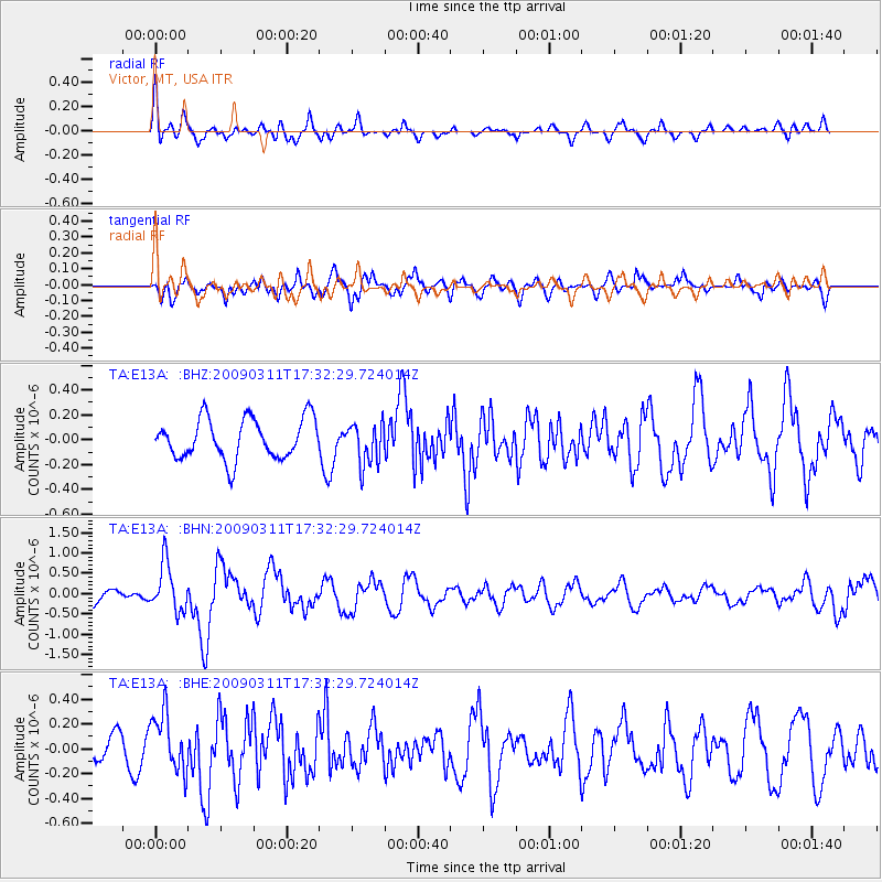
| Radial Match: |
81.97563 % |
| Radial Bump: |
400 |
| Transverse Match: |
63.46982 % |
| Transverse Bump: |
400 |
| SOD ConfigId: |
2658 |
| Insert Time: |
2010-03-06 15:53:50.405 +0000 |
| GWidth: |
2.5 |
| Max Bumps: |
400 |
| Tol: |
0.001 |
|
Signal To Noise
| Channel | StoN | STA | LTA |
| TA:E13A: :BHN:20090311T17:32:29.724014Z | 3.5662014 | 5.879039E-7 | 1.6485438E-7 |
| TA:E13A: :BHE:20090311T17:32:29.724014Z | 2.5066123 | 2.3639977E-7 | 9.4310465E-8 |
| TA:E13A: :BHZ:20090311T17:32:29.724014Z | 1.0439703 | 1.6849246E-7 | 1.6139583E-7 |
| Arrivals |
| Ps | 4.3 SECOND |
| PpPs | 16 SECOND |
| PsPs/PpSs | 20 SECOND |


