You are here: Home > Network List > TA - USArray Transportable Network (new EarthScope stations) Stations List
> Station E13A Victor, MT, USA > Earthquake Result Viewer
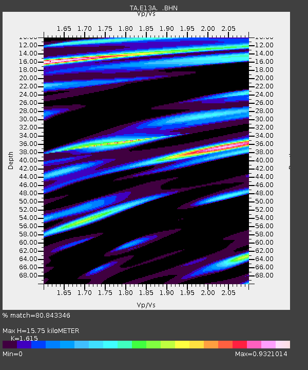
E13A Victor, MT, USA - Earthquake Result Viewer
| Earthquake location: |
South Of Panama |
| Earthquake latitude/longitude: |
5.7/-82.8 |
| Earthquake time(UTC): |
2009/03/12 (071) 23:23:34 GMT |
| Earthquake Depth: |
9.0 km |
| Earthquake Magnitude: |
6.1 MB, 5.9 MS, 6.3 MW, 6.2 MW |
| Earthquake Catalog/Contributor: |
WHDF/NEIC |
|
| Network: |
TA USArray Transportable Network (new EarthScope stations) |
| Station: |
E13A Victor, MT, USA |
| Lat/Lon: |
46.44 N/114.19 W |
| Elevation: |
1257 m |
|
| Distance: |
48.8 deg |
| Az: |
331.384 deg |
| Baz: |
136.432 deg |
| Ray Param: |
0.06910492 |
| Estimated Moho Depth: |
15.75 km |
| Estimated Crust Vp/Vs: |
1.62 |
| Assumed Crust Vp: |
6.622 km/s |
| Estimated Crust Vs: |
4.1 km/s |
| Estimated Crust Poisson's Ratio: |
0.19 |
|
| Radial Match: |
80.843346 % |
| Radial Bump: |
400 |
| Transverse Match: |
70.08753 % |
| Transverse Bump: |
400 |
| SOD ConfigId: |
2658 |
| Insert Time: |
2010-03-06 15:53:52.013 +0000 |
| GWidth: |
2.5 |
| Max Bumps: |
400 |
| Tol: |
0.001 |
|

Signal To Noise
| Channel | StoN | STA | LTA |
| TA:E13A: :BHN:20090312T23:31:49.425011Z | 8.815707 | 1.3610456E-6 | 1.543887E-7 |
| TA:E13A: :BHE:20090312T23:31:49.425011Z | 3.388012 | 5.29799E-7 | 1.5637461E-7 |
| TA:E13A: :BHZ:20090312T23:31:49.425011Z | 3.058896 | 4.3640472E-7 | 1.4266739E-7 |
| Arrivals |
| Ps | 1.6 SECOND |
| PpPs | 5.8 SECOND |
| PsPs/PpSs | 7.4 SECOND |


