You are here: Home > Network List > TA - USArray Transportable Network (new EarthScope stations) Stations List
> Station E13A Victor, MT, USA > Earthquake Result Viewer
E13A Victor, MT, USA - Earthquake Result Viewer
| Earthquake location: |
Kuril Islands |
| Earthquake latitude/longitude: |
46.5/153.3 |
| Earthquake time(UTC): |
2008/06/23 (175) 12:32:12 GMT |
| Earthquake Depth: |
10 km |
| Earthquake Magnitude: |
5.6 MB, 5.2 MS, 5.6 MW, 5.6 MW |
| Earthquake Catalog/Contributor: |
WHDF/NEIC |
|
| Network: |
TA USArray Transportable Network (new EarthScope stations) |
| Station: |
E13A Victor, MT, USA |
| Lat/Lon: |
46.44 N/114.19 W |
| Elevation: |
1257 m |
|
| Distance: |
59.9 deg |
| Az: |
52.959 deg |
| Baz: |
307.096 deg |
| Ray Param: |
0.061860718 |
| Estimated Moho Depth: |
28.0 km |
| Estimated Crust Vp/Vs: |
2.07 |
| Assumed Crust Vp: |
6.622 km/s |
| Estimated Crust Vs: |
3.195 km/s |
| Estimated Crust Poisson's Ratio: |
0.35 |
|
| Radial Match: |
81.72396 % |
| Radial Bump: |
400 |
| Transverse Match: |
70.88475 % |
| Transverse Bump: |
400 |
| SOD ConfigId: |
2504 |
| Insert Time: |
2010-03-06 15:54:36.033 +0000 |
| GWidth: |
2.5 |
| Max Bumps: |
400 |
| Tol: |
0.001 |
|
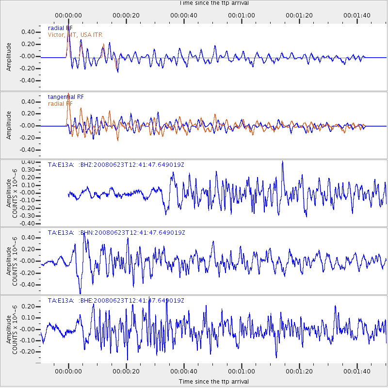
Signal To Noise
| Channel | StoN | STA | LTA |
| TA:E13A: :BHN:20080623T12:41:47.649019Z | 4.966635 | 2.337099E-7 | 4.705598E-8 |
| TA:E13A: :BHE:20080623T12:41:47.649019Z | 1.3417839 | 5.2947986E-8 | 3.946089E-8 |
| TA:E13A: :BHZ:20080623T12:41:47.649019Z | 3.5089865 | 1.2284774E-7 | 3.500946E-8 |
| Arrivals |
| Ps | 4.7 SECOND |
| PpPs | 12 SECOND |
| PsPs/PpSs | 17 SECOND |


