You are here: Home > Network List > TA - USArray Transportable Network (new EarthScope stations) Stations List
> Station E13A Victor, MT, USA > Earthquake Result Viewer
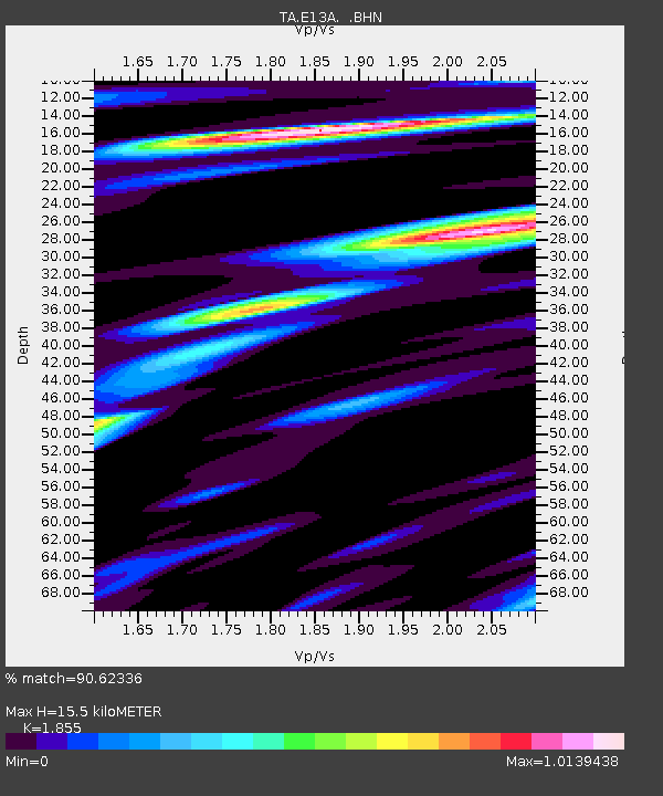
E13A Victor, MT, USA - Earthquake Result Viewer
| Earthquake location: |
Sea Of Okhotsk |
| Earthquake latitude/longitude: |
53.9/152.9 |
| Earthquake time(UTC): |
2008/07/05 (187) 02:12:04 GMT |
| Earthquake Depth: |
633 km |
| Earthquake Magnitude: |
6.8 MB, 7.7 MW, 7.7 MW |
| Earthquake Catalog/Contributor: |
WHDF/NEIC |
|
| Network: |
TA USArray Transportable Network (new EarthScope stations) |
| Station: |
E13A Victor, MT, USA |
| Lat/Lon: |
46.44 N/114.19 W |
| Elevation: |
1257 m |
|
| Distance: |
55.9 deg |
| Az: |
56.557 deg |
| Baz: |
314.406 deg |
| Ray Param: |
0.061760366 |
| Estimated Moho Depth: |
15.5 km |
| Estimated Crust Vp/Vs: |
1.86 |
| Assumed Crust Vp: |
6.622 km/s |
| Estimated Crust Vs: |
3.57 km/s |
| Estimated Crust Poisson's Ratio: |
0.30 |
|
| Radial Match: |
90.62336 % |
| Radial Bump: |
400 |
| Transverse Match: |
77.76565 % |
| Transverse Bump: |
400 |
| SOD ConfigId: |
2504 |
| Insert Time: |
2010-03-06 15:54:42.941 +0000 |
| GWidth: |
2.5 |
| Max Bumps: |
400 |
| Tol: |
0.001 |
|

Signal To Noise
| Channel | StoN | STA | LTA |
| TA:E13A: :BHN:20080705T02:20:13.450001Z | 55.524982 | 5.721119E-6 | 1.03036854E-7 |
| TA:E13A: :BHE:20080705T02:20:13.450001Z | 15.826855 | 1.6775198E-6 | 1.0599199E-7 |
| TA:E13A: :BHZ:20080705T02:20:13.450001Z | 26.014587 | 1.9558888E-6 | 7.518431E-8 |
| Arrivals |
| Ps | 2.1 SECOND |
| PpPs | 6.4 SECOND |
| PsPs/PpSs | 8.5 SECOND |


