You are here: Home > Network List > TA - USArray Transportable Network (new EarthScope stations) Stations List
> Station J26L Joseph Creek, AK, USA > Earthquake Result Viewer
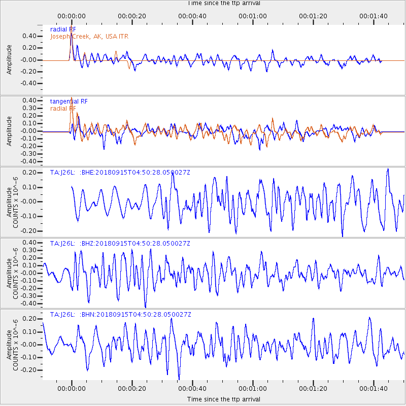
J26L Joseph Creek, AK, USA - Earthquake Result Viewer
*The percent match for this event was below the threshold and hence no stack was calculated.
| Earthquake location: |
Ryukyu Islands, Japan |
| Earthquake latitude/longitude: |
26.7/129.6 |
| Earthquake time(UTC): |
2018/09/15 (258) 04:40:19 GMT |
| Earthquake Depth: |
10 km |
| Earthquake Magnitude: |
5.5 Mww |
| Earthquake Catalog/Contributor: |
NEIC PDE/us |
|
| Network: |
TA USArray Transportable Network (new EarthScope stations) |
| Station: |
J26L Joseph Creek, AK, USA |
| Lat/Lon: |
64.50 N/143.56 W |
| Elevation: |
1144 m |
|
| Distance: |
64.9 deg |
| Az: |
28.502 deg |
| Baz: |
279.451 deg |
| Ray Param: |
$rayparam |
*The percent match for this event was below the threshold and hence was not used in the summary stack. |
|
| Radial Match: |
71.13042 % |
| Radial Bump: |
400 |
| Transverse Match: |
54.872936 % |
| Transverse Bump: |
400 |
| SOD ConfigId: |
13570011 |
| Insert Time: |
2019-05-01 06:16:17.015 +0000 |
| GWidth: |
2.5 |
| Max Bumps: |
400 |
| Tol: |
0.001 |
|
Signal To Noise
| Channel | StoN | STA | LTA |
| TA:J26L: :BHZ:20180915T04:50:28.050027Z | 2.0133853 | 1.6276736E-7 | 8.084263E-8 |
| TA:J26L: :BHN:20180915T04:50:28.050027Z | 0.7160559 | 6.584513E-8 | 9.1955286E-8 |
| TA:J26L: :BHE:20180915T04:50:28.050027Z | 1.837624 | 1.1354996E-7 | 6.1791724E-8 |
| Arrivals |
| Ps | |
| PpPs | |
| PsPs/PpSs | |


