You are here: Home > Network List > TA - USArray Transportable Network (new EarthScope stations) Stations List
> Station E13A Victor, MT, USA > Earthquake Result Viewer
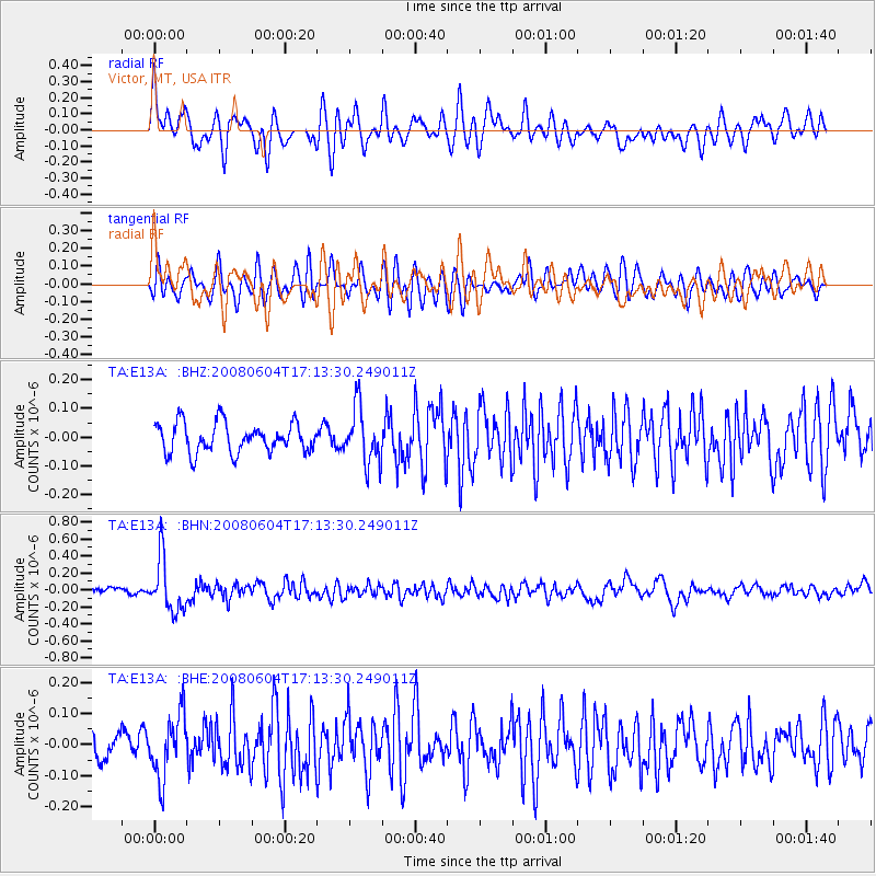
E13A Victor, MT, USA - Earthquake Result Viewer
*The percent match for this event was below the threshold and hence no stack was calculated.
| Earthquake location: |
Hokkaido, Japan Region |
| Earthquake latitude/longitude: |
41.5/139.0 |
| Earthquake time(UTC): |
2008/06/04 (156) 17:03:07 GMT |
| Earthquake Depth: |
213 km |
| Earthquake Magnitude: |
5.5 MB, 5.7 MW, 5.7 MW |
| Earthquake Catalog/Contributor: |
WHDF/NEIC |
|
| Network: |
TA USArray Transportable Network (new EarthScope stations) |
| Station: |
E13A Victor, MT, USA |
| Lat/Lon: |
46.44 N/114.19 W |
| Elevation: |
1257 m |
|
| Distance: |
70.9 deg |
| Az: |
44.487 deg |
| Baz: |
310.465 deg |
| Ray Param: |
$rayparam |
*The percent match for this event was below the threshold and hence was not used in the summary stack. |
|
| Radial Match: |
65.8262 % |
| Radial Bump: |
400 |
| Transverse Match: |
60.39651 % |
| Transverse Bump: |
400 |
| SOD ConfigId: |
2504 |
| Insert Time: |
2010-03-06 15:55:02.694 +0000 |
| GWidth: |
2.5 |
| Max Bumps: |
400 |
| Tol: |
0.001 |
|
Signal To Noise
| Channel | StoN | STA | LTA |
| TA:E13A: :BHN:20080604T17:13:30.249011Z | 5.8714495 | 3.138989E-7 | 5.346191E-8 |
| TA:E13A: :BHE:20080604T17:13:30.249011Z | 2.337216 | 1.000716E-7 | 4.2816584E-8 |
| TA:E13A: :BHZ:20080604T17:13:30.249011Z | 1.8801678 | 9.675408E-8 | 5.146034E-8 |
| Arrivals |
| Ps | |
| PpPs | |
| PsPs/PpSs | |


