You are here: Home > Network List > TA - USArray Transportable Network (new EarthScope stations) Stations List
> Station E13A Victor, MT, USA > Earthquake Result Viewer
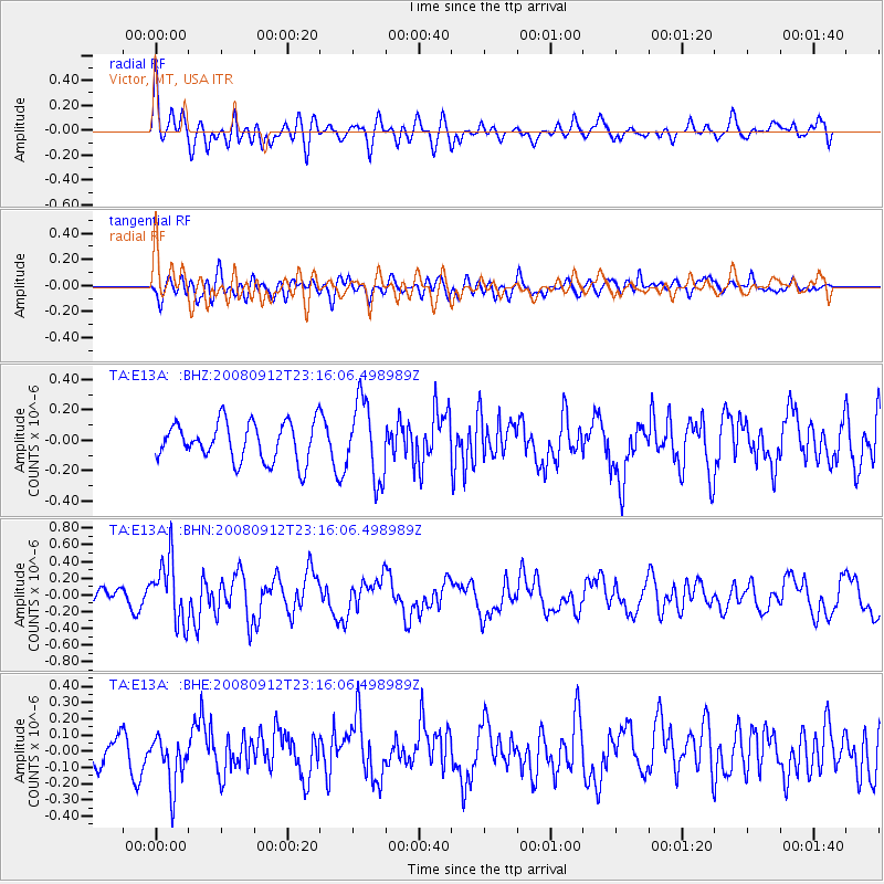
E13A Victor, MT, USA - Earthquake Result Viewer
*The percent match for this event was below the threshold and hence no stack was calculated.
| Earthquake location: |
Komandorskiye Ostrova Region |
| Earthquake latitude/longitude: |
56.3/164.1 |
| Earthquake time(UTC): |
2008/09/12 (256) 23:07:50 GMT |
| Earthquake Depth: |
9.3 km |
| Earthquake Magnitude: |
5.5 MB, 5.7 MS, 5.9 MW, 5.9 MW |
| Earthquake Catalog/Contributor: |
WHDF/NEIC |
|
| Network: |
TA USArray Transportable Network (new EarthScope stations) |
| Station: |
E13A Victor, MT, USA |
| Lat/Lon: |
46.44 N/114.19 W |
| Elevation: |
1257 m |
|
| Distance: |
49.1 deg |
| Az: |
64.942 deg |
| Baz: |
313.104 deg |
| Ray Param: |
$rayparam |
*The percent match for this event was below the threshold and hence was not used in the summary stack. |
|
| Radial Match: |
67.579926 % |
| Radial Bump: |
400 |
| Transverse Match: |
49.579205 % |
| Transverse Bump: |
400 |
| SOD ConfigId: |
2560 |
| Insert Time: |
2010-03-06 15:55:24.066 +0000 |
| GWidth: |
2.5 |
| Max Bumps: |
400 |
| Tol: |
0.001 |
|
Signal To Noise
| Channel | StoN | STA | LTA |
| TA:E13A: :BHN:20080912T23:16:06.498989Z | 5.392227 | 3.7476858E-7 | 6.950163E-8 |
| TA:E13A: :BHE:20080912T23:16:06.498989Z | 2.5044427 | 1.5850976E-7 | 6.329143E-8 |
| TA:E13A: :BHZ:20080912T23:16:06.498989Z | 2.0259483 | 2.5597495E-7 | 1.2634821E-7 |
| Arrivals |
| Ps | |
| PpPs | |
| PsPs/PpSs | |


